Virtual Surveyor
Visita virtual immobiliària i cartografia 3D
Verifica i actualitza el perfil
Els perfils reclamats apareixen a la part superior dels resultats de cerca. Verifica'ls ara, només trigaràs un parell de minuts.
Visita
Informe
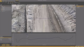
Virtual Surveyor offers advanced drone surveying software designed to improve efficiency in topographic surveying, mining, construction earthworks, and stockpile inventory management.
Features like the Terrain Creator and Virtual Surveyor apps, users can seamlessly transform drone data into actionable insights, ensuring precise reporting and streamlined workflows.
Virtual Surveyor es pot trobar a Real Estate Virtual Tour & 3D Mapping categories.
Els productes més similars a Virtual Surveyor són:
Captures de pantalla
Encara no s'ha penjat cap captura de pantalla. Ets el propietari d'aquest negoci?
Puja captures de pantalla.Vídeos de YouTube
Vídeos del canal oficial de YouTube
(20 videos)


![Balancing Cut and Fill [in PEAK]](https://i.ytimg.com/vi/bfoh-Lw3f5k/mqdefault.jpg)


![Planimetric Surveying [Fast and Simple]](https://i.ytimg.com/vi/bYudnDPf1d0/mqdefault.jpg)
![From Drone Photos to Topographic Surveys [EASY]](https://i.ytimg.com/vi/C4iywCyrctY/mqdefault.jpg)
![Contour lines at bare earth [with Zenmuse L1]](https://i.ytimg.com/vi/ClTtmWF45vY/mqdefault.jpg)
![Stockpile Inventory [with DRONES]](https://i.ytimg.com/vi/JTwOeov5AGI/mqdefault.jpg)
![Surveying curb and gutter [with DRONES]](https://i.ytimg.com/vi/8BEKcYrSnhc/mqdefault.jpg)
![Construction Site Earthworks Monitoring [DIRT]](https://i.ytimg.com/vi/j_R4xs7jJHI/mqdefault.jpg)


Detalls
LinkedIn:
Visita
YouTube:
Visita
Instagram:
Visita
Any d'establiment:
2015
Preus:
€0-€21/mo
Tipus de consumidor:
B2B
Característiques principals de Virtual Surveyor
Beneficis de Virtual Surveyor
Qui hauria d'utilitzar Virtual Surveyor?
Insígnies
Augmenta la teva autoritat SaaS amb una de les nostres insígnies
Alternatives a Virtual Surveyor
Viralsweep Promogut
Viralsweep is a comprehensive viral marketing platform designed to create and...
Prosacco and Sons Enterprise Promogut
Viralsweep is a comprehensive viral marketing platform designed to create and...
Pythagoras
This software suite provides comprehensive tools for surveying, mapping, cons...
Drone Surveying
Drone Surveying offers precise aerial surveys for the house building sector, ...
PocketSurvey
Discover innovative building surveying software and mobile apps designed to e...
Civil Tracker
Civil Tracker offers innovative drone mapping software designed to simplify m...
Seiler GeoDrones
This platform offers comprehensive drone solutions, including advanced aerial...
ESurveying Softech
ESurveying Softech offers a range of online tools for infrastructural enginee...
3Dsurvey
This comprehensive software solution specializes in photogrammetry, mapping, ...
Carlson
This comprehensive land surveying and civil engineering software suite offers...
Explora més en aquesta categoria:
Tecnologies utilitzades
html5shiv
Lightbox2
reCAPTCHA
Freshdesk
Awesome Font
Google Fonts
Google Tag Manager
Animate.css
Freshchat (Freshdesk Messaging)
FontAwesome
CDNJS
CookieConsent by Osano
ASP.NET
Ruby on Rails
HTML5
Wistia
Cloudflare
Wix Content Delivery Network (CDN)
Programa d'afiliats
Programa d'afiliats:
Uneix-te al programa d'afiliats
* Google s'esforça per proporcionar informació precisa i actualitzada sobre recursos web no segurs, però no pot garantir que els resultats siguin complets ni que estiguin lliures d'errors.
** Algunes o totes les parts d'aquesta pàgina poden ser generades per IA, així que verifiqueu qualsevol informació important de manera independent.
Reclamat recentment
Programari de gestió de projectes
Plataformes de màrqueting de continguts
Programari de seguiment del temps i productivitat
Programari d'enquestes i comentaris de clients
Creativitats publicitàries i generació de vídeos amb tecnologia d'IA
Recursos Humans i Contractació
Processament de documents amb tecnologia d'IA
Programari de gestió de projectes
Plataformes de comerç social
Plataformes d'automatització de màrqueting
Afegit recentment
Kanradar
Programari de gestió de projectes
Mera Document
Emmagatzematge al núvol, còpia de seguretat i compartició de fitxers
Shadow Operator
Monitorització i observabilitat d'aplicacions
Theshiwiarsproject
Plataformes d'automatització de màrqueting
Remunara
Programari de gestió de compensacions
Wisething
Eines de planificació financera i pressupost
Hotel Pulse
Programari de gestió hotelera
Ecoinch
Programari de gestió de compliment
CryptoFreeSignal
Plataformes de negociació i corretatge d'accions
MedSov
Sistemes de registre electrònic de salut (EHR)
Les 10 categories principals d'aquest mes
1.
Plataformes de negociació i corretatge d'accions
+759
Nombre de nous productes SaaS afegits a aquesta categoria en els darrers 30 dies.
2.
Automatització del flux de treball i RPA
+598
Nombre de nous productes SaaS afegits a aquesta categoria en els darrers 30 dies.
3.
Eines de selecció de currículums amb intel·ligència artificial
+385
Nombre de nous productes SaaS afegits a aquesta categoria en els darrers 30 dies.
4.
Programari d'automatització de vendes
+339
Nombre de nous productes SaaS afegits a aquesta categoria en els darrers 30 dies.
5.
Plataformes AutoML
+335
Nombre de nous productes SaaS afegits a aquesta categoria en els darrers 30 dies.
6.
Programari de gestió escolar
+299
Nombre de nous productes SaaS afegits a aquesta categoria en els darrers 30 dies.
7.
Eines de planificació financera i pressupost
+286
Nombre de nous productes SaaS afegits a aquesta categoria en els darrers 30 dies.
8.
Seguiment de salut i forma física
+263
Nombre de nous productes SaaS afegits a aquesta categoria en els darrers 30 dies.
9.
Avatars virtuals i assistents digitals amb intel·ligència artificial
+262
Nombre de nous productes SaaS afegits a aquesta categoria en els darrers 30 dies.
10.
Eines d'edició i conversió de PDF
+249
Nombre de nous productes SaaS afegits a aquesta categoria en els darrers 30 dies.
Estadístiques del navegador SaaS
Afegit els darrers 30 dies
+23,810
Nombre de nous productes SaaS descoberts i afegits a la nostra base de dades en els darrers 30 dies.
SaaS actiu
463,858
Nombre total de productes SaaS publicats i actius que actualment estan indexats al nostre motor de cerca.
Total a la base de dades
1,309,358
Nombre total de tots els productes SaaS de la nostra base de dades, incloses les entrades no publicades i descontinuades.
Uneix-te gratuïtament al navegador SaaS
Utilitza tots els filtres avançats gratuïtament
Gestiona els teus anuncis SaaS
Crea alertes gratuïtes per a nous SaaS
Patrocinat
SendShort
Eines d'edició de vídeo i animació amb intel·ligència artificial
LowFruits
Eines de recerca de paraules clau
Diginius
Plataformes d'automatització de màrqueting
eSignBase
Eines de gestió documental i signatura electrònica
Startup For Startups
Plataformes de màrqueting de continguts
LatePoint
Programari de programació de cites
Serpple
Eines de recerca de paraules clau
DivParser
API i proxies de scraping web
Ziggma
Gestió de carteres d'inversions
Signaturely
Eines de gestió documental i signatura electrònica
No t'ho perdis, sigues el primer a saber-ho!
Cada dia es llancen nous productes SaaS, 23,810 afegits només en els darrers 30 dies. Mantingueu-vos informats i sigueu els primers a saber quan el navegador SaaS descobreixi nous productes SaaS que coincideixin amb la vostra consulta de cerca.
Inicia sessió per configurar alertes per correu electrònic de nous SaaS que coincideixin amb la teva cerca.
Inicia sessió per crear una alerta
Explora eines similars
Navega-ho tot →