InSite Software
Software til byggeafgang
Få bekræftet og opdater profil
Profiler, der er gjort krav på, vises øverst i søgeresultaterne. Bliv bekræftet nu, det tager kun et par minutter.
Besøg
Rapport
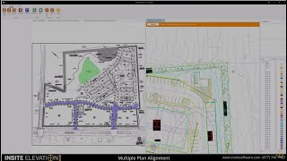
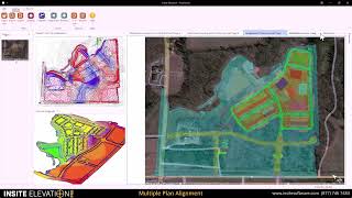
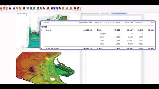
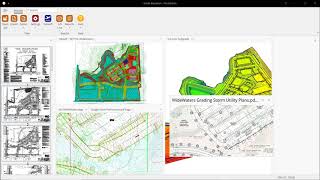
This software solution streamlines the process of earthwork and utility estimation by providing accurate takeoff and GPS modeling capabilities, enabling professionals to efficiently manage complex site calculations. Key features include support for CAD, PDF, and drone data integration, precise quantity validation through advanced contour mapping, and seamless export to various machine control systems, ultimately solving challenges related to time management, accuracy, and communication for estimators and construction professionals.
InSite Software kan findes i Construction Takeoff Software kategorier.
De produkter, der ligner InSite Software mest, er:
Skærmbilleder
Der er endnu ikke uploadet nogen skærmbilleder. Ejer du denne virksomhed?
Upload skærmbilleder.YouTube-videoer
Videoer fra den officielle YouTube-kanal
(20 videos)


Detaljer
InSite Software Hovedfunktioner
InSite Software fordele
Hvem bør bruge InSite Software?
Badges
Øg din SaaS-autoritet med et af vores badges
InSite Software Alternativer
Contractor Foreman Forfremmet
This comprehensive construction management platform streamlines the coordinat...
Carlson
This comprehensive land surveying and civil engineering software suite offers...
Rockpile Solutions
A comprehensive software suite that optimizes workflows, automates repetitive...
3Dsurvey
This comprehensive software solution specializes in photogrammetry, mapping, ...
Promine
This software suite enhances the efficiency and accuracy of mining and survey...
Pythagoras
This software suite provides comprehensive tools for surveying, mapping, cons...
Stringer
This software enhances productivity and accuracy in civil engineering and lan...
Buildsoft
This software suite streamlines the estimating and takeoff processes for cons...
Udforsk mere i denne kategori:
Anvendte teknologier
Google reCAPTCHA
Yeost SEO Plugin
Tailwind
Cloudflare
WordPress
Google Site Verification
Google Tag Manager for WordPress (GTM4WP)
Gravity Forms
HTML5
reCAPTCHA
Wix Content Delivery Network (CDN)
WordPress Block Editor (Gutenberg)
WordPress REST API
WP Engine
Google Fonts
Slick Slider
Capterra
* Google bestræber sig på at levere nøjagtige og opdaterede oplysninger om usikre webressourcer, men kan ikke garantere fuldstændighed eller fejlfri resultater.
** Nogle eller alle dele af denne side kan være genereret af kunstig intelligens, så verificér venligst alle kritiske oplysninger uafhængigt.
Nyligt gjort krav på
Software til medarbejderovervågning
API-sikkerhed
Værktøjer til filkonvertering
API- og backend-as-a-service-platforme
Quiz- og vurderingssoftware
Software til optimering af markedspladspriser
Dokumentationsværktøjer til udviklere
Restaurant POS & Management Systemer
Versionskontrol og Git-hosting
AI-drevne CV-screeningsværktøjer
Nyligt tilføjet
EasyCardScan
Kontakthåndteringssoftware
Yojiq
Marketingautomatiseringsplatforme
SellerPlanKit
Software til optimering af markedspladspriser
Muon Labs
Workflowautomatisering og RPA
SpidereKart
Multikanal e-handelsstyring
PlanBatch
Administration og planlægning af sociale medier
Vietecom
Indholdsmarkedsføringsplatforme
Stay Green
Fjernarbejdestyring og produktivitetssporing
Homeroom
Skoleadministrationssoftware
SKUFix
Regnskabssoftware
Top 10 kategorier denne måned
1.
Aktiehandels- og mæglerplatforme
+1,053
Antal nye SaaS-produkter tilføjet til denne kategori i de seneste 30 dage.
2.
Workflowautomatisering og RPA
+827
Antal nye SaaS-produkter tilføjet til denne kategori i de seneste 30 dage.
3.
AI-drevne CV-screeningsværktøjer
+594
Antal nye SaaS-produkter tilføjet til denne kategori i de seneste 30 dage.
4.
AutoML-platforme
+528
Antal nye SaaS-produkter tilføjet til denne kategori i de seneste 30 dage.
5.
Salgsautomatiseringssoftware
+477
Antal nye SaaS-produkter tilføjet til denne kategori i de seneste 30 dage.
6.
Finansiel planlægning og budgetteringsværktøjer
+449
Antal nye SaaS-produkter tilføjet til denne kategori i de seneste 30 dage.
7.
AI-drevne virtuelle avatarer og digitale assistenter
+415
Antal nye SaaS-produkter tilføjet til denne kategori i de seneste 30 dage.
8.
Skoleadministrationssoftware
+401
Antal nye SaaS-produkter tilføjet til denne kategori i de seneste 30 dage.
9.
Sundheds- og fitnesssporing
+395
Antal nye SaaS-produkter tilføjet til denne kategori i de seneste 30 dage.
10.
Restaurant POS & Management Systemer
+336
Antal nye SaaS-produkter tilføjet til denne kategori i de seneste 30 dage.
SaaS-browserstatistik
Tilføjet de seneste 30 dage
+35,678
Antal nye SaaS-produkter opdaget og tilføjet til vores database i de sidste 30 dage.
Aktiv SaaS
483,714
Samlet antal publicerede og aktive SaaS-produkter, der i øjeblikket er indekseret i vores søgemaskine.
Total i databasen
1,357,376
Samlet antal af alle SaaS-produkter i vores database, inklusive ikke-publicerede og udgåede poster.
Tilmeld dig SaaS Browser gratis
Brug alle avancerede filtre gratis
Administrer dine SaaS-lister
Opret gratis alarmer til nye SaaS-løsninger
Sponsoreret
Offorte
Projektstyringssoftware
OneStream Live
Streaming- og live-udsendelsesplatforme
FullCertified
Quiz- og vurderingssoftware
RentEase Uganda
Administration af udlejningsejendomme
Kure
Projektstyringssoftware
Keyword.com
Business Intelligence og analyse
LowFruits
Værktøjer til søgeordsanalyse
GenPage
Leadgenereringssoftware
SendShort
AI-drevne videoredigerings- og animationsværktøjer
Viralsweep
Nyhedsbrevsplatforme
Gå ikke glip af det, vær den første til at vide det!
Nye SaaS-produkter lanceres hver dag, 35,678 er blevet tilføjet alene i de sidste 30 dage. Hold dig informeret, og vær den første til at vide, når SaaS Browser opdager nye SaaS-produkter, der matcher din søgeforespørgsel.
Log ind for at opsætte e-mailalarmer for nye SaaS, der matcher din søgning.
Log ind for at oprette alarm
Udforsk lignende værktøjer
Gennemse alle →