ચકાસણી કરાવો અને પ્રોફાઇલ અપડેટ કરો
દાવો કરાયેલ પ્રોફાઇલ્સ શોધ પરિણામોમાં ટોચ પર જાય છે. હમણાં જ ચકાસણી કરાવો, તેમાં ફક્ત બે મિનિટ લાગે છે.
મુલાકાત
રિપોર્ટ
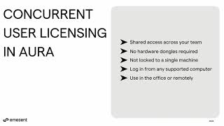
This advanced technology enables precise mapping and data capture in challenging environments, enhancing operational efficiency and safety. Key features include autonomous LiDAR mapping, versatile accessory integration, and real-time data processing, addressing issues such as hazardous site assessments and GPS-denied areas, making it ideal for industries like mining, construction, and public safety.
Emesent માં મળી શકે છે Mapping & Geographic Information Platform (GIS) શ્રેણીઓ.
Emesent સાથે સૌથી વધુ સમાન ઉત્પાદનો છે:
સ્ક્રીનશૉટ્સ
હજુ સુધી કોઈ સ્ક્રીનશોટ અપલોડ કરવામાં આવ્યા નથી. શું તમે આ વ્યવસાયના માલિક છો?
સ્ક્રીનશોટ અપલોડ કરો.YouTube વિડિઓઝ
અધિકૃત YouTube ચેનલના વિડિઓઝ
(20 videos)


વિગતો
LinkedIn:
મુલાકાત
YouTube:
મુલાકાત
Facebook:
મુલાકાત
X:
મુલાકાત
સ્થાપના વર્ષ:
2018
ગ્રાહક પ્રકાર:
B2B
Emesent મુખ્ય લાક્ષણિકતાઓ
Emesent લાભો
Emesent કોણે વાપરવું જોઈએ?
બેજેસ
અમારા બેજમાંથી એક વડે તમારી SaaS સત્તા વધારો
Emesent વિકલ્પો
WebScraping બઢતી
This AI-powered web scraping solution automates the extraction of data from w...
GeoSpatial Technologies
This technology provides real-time tracking and advanced mapping solutions fo...
Yuneec
This advanced aerial technology is designed for a variety of commercial appli...
Airbox
This advanced mapping technology and software suite enhances situational awar...
આ શ્રેણીમાં વધુ શોધખોળ કરો:
વપરાયેલી ટેકનોલોજીઓ
Weglot
Yeost SEO Plugin
Google Tag Manager
Tailwind
Hubspot
Cloudfront
HTML5
WordPress
Cloudflare
Wix Content Delivery Network (CDN)
એફિલિએટ પ્રોગ્રામ
એફિલિએટ પ્રોગ્રામ:
એફિલિએટ પ્રોગ્રામમાં જોડાઓ
* Google અસુરક્ષિત વેબ સંસાધનો પર સચોટ, અપ-ટૂ-ડેટ માહિતી પ્રદાન કરવાનો પ્રયાસ કરે છે પરંતુ સંપૂર્ણતા અથવા ભૂલ-મુક્ત પરિણામોની ગેરંટી આપી શકતું નથી.
** આ પૃષ્ઠના કેટલાક અથવા બધા ભાગો AI દ્વારા જનરેટ કરેલ હોઈ શકે છે, તેથી કૃપા કરીને કોઈપણ મહત્વપૂર્ણ માહિતી સ્વતંત્ર રીતે ચકાસો.
તાજેતરમાં દાવો કરાયેલ
ઇમેઇલ માર્કેટિંગ સોફ્ટવેર
એકાઉન્ટિંગ સોફ્ટવેર
ડેટા વિશ્લેષણ અને વિઝ્યુલાઇઝેશન સોફ્ટવેર
પેરોલ મેનેજમેન્ટ સોફ્ટવેર
નાણાકીય આયોજન અને બજેટ સાધનો
શિક્ષણ અને શિક્ષણ પ્લેટફોર્મ
બિઝનેસ ઇન્ટેલિજન્સ અને એનાલિટિક્સ
SEO સાધનો
બિઝનેસ ઇન્ટેલિજન્સ અને એનાલિટિક્સ
સંપર્ક વ્યવસ્થાપન સોફ્ટવેર
તાજેતરમાં ઉમેરાયેલ
Mr.Producer
રિયલ એસ્ટેટ CRM અને લીડ મેનેજમેન્ટ
WesternHomes
જમીન રોકાણ અને જમીન ફ્લિપિંગ સોફ્ટવેર
Zippoorganize
ક્લાઉડ સ્ટોરેજ, બેકઅપ અને ફાઇલ શેરિંગ
Recapt
ભૂલ ટ્રેકિંગ અને બગ રિપોર્ટિંગ
TradeRaft
સ્ટોક ટ્રેડિંગ અને બ્રોકરેજ પ્લેટફોર્મ્સ
Gymb
સુવિધા વ્યવસ્થાપન સોફ્ટવેર
Private Tracker
આરોગ્ય અને ફિટનેસ ટ્રેકિંગ
ManageOps360
MSPs માટે રિમોટ મોનિટરિંગ અને મેનેજમેન્ટ (RMM)
ManagerAI
સ્કૂલ મેનેજમેન્ટ સોફ્ટવેર
MDBase
AI-સંચાલિત નિદાન અને આરોગ્યસંભાળ વિશ્લેષણ
આ મહિનાની ટોચની 10 શ્રેણીઓ
1.
સેલ્સ ઓટોમેશન સોફ્ટવેર
+856
છેલ્લા 30 દિવસમાં આ શ્રેણીમાં ઉમેરાયેલા નવા SaaS ઉત્પાદનોની સંખ્યા.
2.
બ્લોકચેન અને NFT મેનેજમેન્ટ પ્લેટફોર્મ્સ
+592
છેલ્લા 30 દિવસમાં આ શ્રેણીમાં ઉમેરાયેલા નવા SaaS ઉત્પાદનોની સંખ્યા.
3.
દસ્તાવેજ વ્યવસ્થાપન અને ઇ-સિગ્નેચર ટૂલ્સ
+522
છેલ્લા 30 દિવસમાં આ શ્રેણીમાં ઉમેરાયેલા નવા SaaS ઉત્પાદનોની સંખ્યા.
4.
AI-સંચાલિત વર્ચ્યુઅલ અવતાર અને ડિજિટલ સહાયકો
+497
છેલ્લા 30 દિવસમાં આ શ્રેણીમાં ઉમેરાયેલા નવા SaaS ઉત્પાદનોની સંખ્યા.
5.
ક્લાઉડ સુરક્ષા અને પાલન સાધનો
+493
છેલ્લા 30 દિવસમાં આ શ્રેણીમાં ઉમેરાયેલા નવા SaaS ઉત્પાદનોની સંખ્યા.
6.
AI-સંચાલિત રિઝ્યુમ સ્ક્રીનીંગ ટૂલ્સ
+489
છેલ્લા 30 દિવસમાં આ શ્રેણીમાં ઉમેરાયેલા નવા SaaS ઉત્પાદનોની સંખ્યા.
7.
AI-સંચાલિત નિદાન અને આરોગ્યસંભાળ વિશ્લેષણ
+445
છેલ્લા 30 દિવસમાં આ શ્રેણીમાં ઉમેરાયેલા નવા SaaS ઉત્પાદનોની સંખ્યા.
8.
AI-સંચાલિત કાનૂની સંશોધન પ્લેટફોર્મ
+433
છેલ્લા 30 દિવસમાં આ શ્રેણીમાં ઉમેરાયેલા નવા SaaS ઉત્પાદનોની સંખ્યા.
9.
શિક્ષણ અને શિક્ષણ પ્લેટફોર્મ
+426
છેલ્લા 30 દિવસમાં આ શ્રેણીમાં ઉમેરાયેલા નવા SaaS ઉત્પાદનોની સંખ્યા.
10.
ફ્લીટ મેનેજમેન્ટ સોફ્ટવેર
+422
છેલ્લા 30 દિવસમાં આ શ્રેણીમાં ઉમેરાયેલા નવા SaaS ઉત્પાદનોની સંખ્યા.
SaaS બ્રાઉઝર આંકડા
છેલ્લા 30 દિવસમાં ઉમેરાયેલ
+21,811
છેલ્લા 30 દિવસમાં શોધાયેલા અને અમારા ડેટાબેઝમાં ઉમેરાયેલા નવા SaaS ઉત્પાદનોની સંખ્યા.
સક્રિય SaaS
468,001
અમારા સર્ચ એન્જિનમાં હાલમાં ઇન્ડેક્સ કરાયેલા પ્રકાશિત અને સક્રિય SaaS ઉત્પાદનોની કુલ સંખ્યા.
ડેટાબેઝમાં કુલ
1,296,182
અમારા ડેટાબેઝમાં બધા SaaS ઉત્પાદનોની કુલ સંખ્યા, જેમાં અપ્રકાશિત અને બંધ કરાયેલી એન્ટ્રીઓનો સમાવેશ થાય છે.
SaaS બ્રાઉઝરમાં મફતમાં જોડાઓ
બધા અદ્યતન ફિલ્ટર્સનો મફતમાં ઉપયોગ કરો
તમારી SaaS સૂચિઓનું સંચાલન કરો
નવા SaaS માટે મફત ચેતવણીઓ બનાવો
પ્રાયોજિત
BookingPress
એપોઇન્ટમેન્ટ શેડ્યુલિંગ સોફ્ટવેર
Viralsweep
SMS અને WhatsApp માર્કેટિંગ ટૂલ્સ
Sertifier
પ્રમાણપત્ર, પરીક્ષા અને મૂલ્યાંકનની તૈયારી
Uxcel
પ્રમાણપત્ર, પરીક્ષા અને મૂલ્યાંકનની તૈયારી
DrawSQL
ડેટા વિશ્લેષણ અને વિઝ્યુલાઇઝેશન સોફ્ટવેર
Buffer
સોશિયલ મીડિયા મેનેજમેન્ટ અને શેડ્યુલિંગ
Harpoon
નાણાકીય આયોજન અને બજેટ સાધનો
Inlinks
SEO સાધનો
Clockify
સમય ટ્રેકિંગ અને ઉત્પાદકતા સોફ્ટવેર
Snaptually
AI-સંચાલિત વર્ચ્યુઅલ અવતાર અને ડિજિટલ સહાયકો
ચૂકશો નહીં, સૌથી પહેલા જાણો!
દરરોજ નવા SaaS ઉત્પાદનો લોન્ચ થઈ રહ્યા છે, છેલ્લા 30 દિવસમાં જ 21,811 ઉમેરાયું છે. માહિતગાર રહો, અને SaaS બ્રાઉઝર દ્વારા તમારી શોધ ક્વેરી સાથે મેળ ખાતી નવી SaaS શોધાય ત્યારે સૌ પ્રથમ જાણો.
તમારી શોધ સાથે મેળ ખાતી નવી SaaS માટે ઇમેઇલ ચેતવણીઓ સેટ કરવા માટે સાઇન ઇન કરો.
ચેતવણી બનાવવા માટે સાઇન ઇન કરો
સમાન સાધનોનું અન્વેષણ કરો
બધું બ્રાઉઝ કરો →