Virtual Surveyor
Tour virtuale immobiliare e mappatura 3D
Ottieni la verifica e aggiorna il profilo
I profili rivendicati vengono visualizzati in cima ai risultati di ricerca. Verificali subito, ci vogliono solo un paio di minuti.
Visita
Rapporto
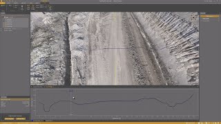
Virtual Surveyor offers advanced drone surveying software designed to improve efficiency in topographic surveying, mining, construction earthworks, and stockpile inventory management.
Features like the Terrain Creator and Virtual Surveyor apps, users can seamlessly transform drone data into actionable insights, ensuring precise reporting and streamlined workflows.
Virtual Surveyor può essere trovato in Real Estate Virtual Tour & 3D Mapping categorie.
I prodotti più simili a Virtual Surveyor sono:
Schermate
Non sono ancora stati caricati screenshot. Sei il proprietario di questa attività?
Carica screenshot.Video di YouTube
Video dal canale YouTube ufficiale
(20 videos)


![Balancing Cut and Fill [in PEAK]](https://i.ytimg.com/vi/bfoh-Lw3f5k/mqdefault.jpg)


![Planimetric Surveying [Fast and Simple]](https://i.ytimg.com/vi/bYudnDPf1d0/mqdefault.jpg)
![From Drone Photos to Topographic Surveys [EASY]](https://i.ytimg.com/vi/C4iywCyrctY/mqdefault.jpg)
![Contour lines at bare earth [with Zenmuse L1]](https://i.ytimg.com/vi/ClTtmWF45vY/mqdefault.jpg)
![Stockpile Inventory [with DRONES]](https://i.ytimg.com/vi/JTwOeov5AGI/mqdefault.jpg)
![Surveying curb and gutter [with DRONES]](https://i.ytimg.com/vi/8BEKcYrSnhc/mqdefault.jpg)
![Construction Site Earthworks Monitoring [DIRT]](https://i.ytimg.com/vi/j_R4xs7jJHI/mqdefault.jpg)


Dettagli
LinkedIn:
Visita
YouTube:
Visita
Instagram:
Visita
Anno di fondazione:
2015
Prezzi:
€0-€21/mo
Tipo di consumatore:
B2B
Virtual Surveyor Caratteristiche principali
Virtual Surveyor Benefici
Chi dovrebbe usare Virtual Surveyor?
Distintivi
Aumenta la tua autorità SaaS con uno dei nostri badge
Virtual Surveyor Alternative
Viralsweep Promosso
Viralsweep is a comprehensive viral marketing platform designed to create and...
Pythagoras
This software suite provides comprehensive tools for surveying, mapping, cons...
Drone Surveying
Drone Surveying offers precise aerial surveys for the house building sector, ...
PocketSurvey
Discover innovative building surveying software and mobile apps designed to e...
Civil Tracker
Civil Tracker offers innovative drone mapping software designed to simplify m...
Seiler GeoDrones
This platform offers comprehensive drone solutions, including advanced aerial...
ESurveying Softech
ESurveying Softech offers a range of online tools for infrastructural enginee...
3Dsurvey
This comprehensive software solution specializes in photogrammetry, mapping, ...
Carlson
This comprehensive land surveying and civil engineering software suite offers...
Esplora di più in questa categoria:
Tecnologie utilizzate
html5shiv
Lightbox2
reCAPTCHA
Freshdesk
Awesome Font
Google Fonts
Google Tag Manager
Animate.css
Freshchat (Freshdesk Messaging)
FontAwesome
CDNJS
CookieConsent by Osano
ASP.NET
Ruby on Rails
HTML5
Wistia
Cloudflare
Wix Content Delivery Network (CDN)
Visualizza tutte le tecnologie
Programma di affiliazione
Programma di affiliazione:
Partecipa al programma di affiliazione
* Google si impegna a fornire informazioni accurate e aggiornate sulle risorse web non sicure, ma non può garantire la completezza o l'assenza di errori nei risultati.
** Alcune o tutte le parti di questa pagina potrebbero essere generate dall'intelligenza artificiale, pertanto ti preghiamo di verificare in modo indipendente qualsiasi informazione critica.
Richiesto di recente
Scrittura e generazione di testi basate sull'intelligenza artificiale
Software di monitoraggio del tempo e produttività
Risorse umane e reclutamento
Software di gestione dei contatti
Strumenti di gestione dei documenti e firma elettronica
Monitoraggio, disponibilità e prestazioni del sito web
Piattaforma di intelligenza collettiva
Soluzioni per la gestione dei servizi sul campo
Strumenti di pianificazione finanziaria e di budgeting
Piattaforme di content marketing
Aggiunti di recente
Oryx DTR
Gestione dell'e-commerce multicanale
AgentDelivery
Costruttori di agenti di intelligenza artificiale
InsurX
InsurTech e amministrazione delle politiche
Nexus
Sistemi di gestione dei contenuti (CMS)
Trading
Piattaforme di trading e intermediazione azionaria
RelistHQ
Strumenti per venditori eBay ed Etsy
Statulator
Software di analisi e visualizzazione dei dati
d11cloud
Infrastruttura cloud e piattaforme IaaS
HubSegment
CRM (gestione delle relazioni con i clienti)
Workable
Strumenti di pianificazione e programmazione della produzione
Le 10 categorie principali di questo mese
1.
Piattaforme di trading e intermediazione azionaria
+759
Numero di nuovi prodotti SaaS aggiunti a questa categoria negli ultimi 30 giorni.
2.
Automazione dei flussi di lavoro e RPA
+598
Numero di nuovi prodotti SaaS aggiunti a questa categoria negli ultimi 30 giorni.
3.
Strumenti di screening dei curriculum basati sull'intelligenza artificiale
+385
Numero di nuovi prodotti SaaS aggiunti a questa categoria negli ultimi 30 giorni.
4.
Software di automazione delle vendite
+339
Numero di nuovi prodotti SaaS aggiunti a questa categoria negli ultimi 30 giorni.
5.
Piattaforme AutoML
+335
Numero di nuovi prodotti SaaS aggiunti a questa categoria negli ultimi 30 giorni.
6.
Software per la gestione scolastica
+299
Numero di nuovi prodotti SaaS aggiunti a questa categoria negli ultimi 30 giorni.
7.
Strumenti di pianificazione finanziaria e di budgeting
+286
Numero di nuovi prodotti SaaS aggiunti a questa categoria negli ultimi 30 giorni.
8.
Monitoraggio della salute e del fitness
+263
Numero di nuovi prodotti SaaS aggiunti a questa categoria negli ultimi 30 giorni.
9.
Avatar virtuali e assistenti digitali basati sull'intelligenza artificiale
+262
Numero di nuovi prodotti SaaS aggiunti a questa categoria negli ultimi 30 giorni.
10.
Strumenti di modifica e conversione PDF
+249
Numero di nuovi prodotti SaaS aggiunti a questa categoria negli ultimi 30 giorni.
Statistiche del browser SaaS
Aggiunto negli ultimi 30 giorni
+23,810
Numero di nuovi prodotti SaaS scoperti e aggiunti al nostro database negli ultimi 30 giorni.
SaaS attivo
463,858
Numero totale di prodotti SaaS pubblicati e attivi attualmente indicizzati nel nostro motore di ricerca.
Totale nel database
1,309,358
Numero totale di tutti i prodotti SaaS presenti nel nostro database, comprese le voci non pubblicate e non più in produzione.
Iscriviti gratuitamente a SaaS Browser
Utilizza gratuitamente tutti i filtri avanzati
Gestisci i tuoi annunci SaaS
Crea avvisi gratuiti per nuovi SaaS
Sponsorizzato
SmartTask
Gestione del lavoro a distanza e monitoraggio della produttività
RentEase Uganda
Gestione degli immobili in affitto
Centripe
Piattaforme di coinvolgimento delle vendite
Sniply
Servizi di accorciamento URL e gestione dei link
Nuelink
Gestione e programmazione dei social media
Hello Audio
Piattaforme per audiolibri e contenuti audio parlati
G Maps Extractor
Software SEO locale
TotePilot
Gestione magazzino e inventario
SalesMind AI
Software di generazione di lead
Draftbit
Costruttori di app senza codice basati sull'intelligenza artificiale
Non perderti questa novità, scoprila per primo!
Ogni giorno vengono lanciati nuovi prodotti SaaS, 23,810 solo negli ultimi 30 giorni. Rimani aggiornato e scopri per primo quando SaaS Browser scopre nuovi prodotti SaaS corrispondenti alla tua query di ricerca.
Accedi per configurare avvisi email per i nuovi SaaS che corrispondono alla tua ricerca.
Accedi per creare un avviso
Esplora strumenti simili
Sfoglia tutto →