പരിശോധിച്ചുറപ്പിച്ച് പ്രൊഫൈൽ അപ്ഡേറ്റ് ചെയ്യുക
ക്ലെയിം ചെയ്ത പ്രൊഫൈലുകൾ തിരയൽ ഫലങ്ങളുടെ മുകളിലേക്ക് പോകുന്നു. ഇപ്പോൾ പരിശോധിച്ചുറപ്പിക്കൂ, ഇതിന് കുറച്ച് മിനിറ്റുകൾ മാത്രമേ എടുക്കൂ.
സന്ദർശിക്കുക
റിപ്പോർട്ട് ചെയ്യുക
This advanced technology enables precise mapping and data capture in challenging environments, enhancing operational efficiency and safety. Key features include autonomous LiDAR mapping, versatile accessory integration, and real-time data processing, addressing issues such as hazardous site assessments and GPS-denied areas, making it ideal for industries like mining, construction, and public safety.
Emesent ഇതിൽ കാണാം Mapping & Geographic Information Platform (GIS) വിഭാഗങ്ങൾ.
Emesent ന് ഏറ്റവും സമാനമായ ഉൽപ്പന്നങ്ങൾ ഇവയാണ്:
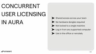
സ്ക്രീൻഷോട്ടുകൾ
ഇതുവരെ സ്ക്രീൻഷോട്ടുകളൊന്നും അപ്ലോഡ് ചെയ്തിട്ടില്ല. ഈ ബിസിനസ്സ് നിങ്ങളുടേതാണോ?
സ്ക്രീൻഷോട്ടുകൾ അപ്ലോഡ് ചെയ്യുക.YouTube വീഡിയോകൾ
ഔദ്യോഗിക YouTube ചാനലിൽ നിന്നുള്ള വീഡിയോകൾ
(20 videos)


വിശദാംശങ്ങൾ
LinkedIn:
സന്ദർശിക്കുക
YouTube:
സന്ദർശിക്കുക
Facebook:
സന്ദർശിക്കുക
X:
സന്ദർശിക്കുക
സ്ഥാപിതമായ വർഷം:
2018
ഉപഭോക്തൃ തരം:
B2B
അവലോകനങ്ങൾ
–
0 അവലോകനങ്ങൾ
5
–
4
–
3
–
2
–
1
–
Emesent പ്രധാന സവിശേഷതകൾ
Emesent ആനുകൂല്യങ്ങൾ
ആരാണ് Emesent ഉപയോഗിക്കേണ്ടത്?
ബാഡ്ജുകൾ
ഞങ്ങളുടെ ബാഡ്ജുകളിൽ ഒന്ന് ഉപയോഗിച്ച് നിങ്ങളുടെ SaaS അധികാരം വർദ്ധിപ്പിക്കുക
Emesent ഇതരമാർഗങ്ങൾ
WebScraping പ്രമോട്ടുചെയ്തു
This AI-powered web scraping solution automates the extraction of data from w...
GeoSpatial Technologies
This technology provides real-time tracking and advanced mapping solutions fo...
Yuneec
This advanced aerial technology is designed for a variety of commercial appli...
Airbox
This advanced mapping technology and software suite enhances situational awar...
ഈ വിഭാഗത്തിൽ കൂടുതൽ പര്യവേക്ഷണം ചെയ്യുക:
ഉപയോഗിച്ച സാങ്കേതികവിദ്യകൾ
Weglot
Yeost SEO Plugin
Google Tag Manager
Tailwind
Hubspot
Cloudfront
HTML5
WordPress
Cloudflare
Wix Content Delivery Network (CDN)
എല്ലാ സാങ്കേതികവിദ്യകളും കാണുക
അഫിലിയേറ്റ് പ്രോഗ്രാം
അഫിലിയേറ്റ് പ്രോഗ്രാം:
അഫിലിയേറ്റ് പ്രോഗ്രാമിൽ ചേരുക
* സുരക്ഷിതമല്ലാത്ത വെബ് ഉറവിടങ്ങളെക്കുറിച്ച് കൃത്യവും കാലികവുമായ വിവരങ്ങൾ നൽകാൻ Google ശ്രമിക്കുന്നു, പക്ഷേ പൂർണ്ണതയോ പിശകുകളില്ലാത്ത ഫലങ്ങളോ ഉറപ്പുനൽകാൻ കഴിയില്ല.
** ഈ പേജിന്റെ ചില ഭാഗങ്ങളോ എല്ലാ ഭാഗങ്ങളോ AI സൃഷ്ടിച്ചതാകാം, അതിനാൽ ഏതെങ്കിലും നിർണായക വിവരങ്ങൾ സ്വതന്ത്രമായി പരിശോധിക്കുക.
അടുത്തിടെ ക്ലെയിം ചെയ്തത്
ടൂർ & ആക്റ്റിവിറ്റി മാനേജ്മെന്റ് സോഫ്റ്റ്വെയർ
SEO ഉപകരണങ്ങൾ
ജീവനക്കാരുടെ ഓൺബോർഡിംഗ് & പരിശീലന സോഫ്റ്റ്വെയർ
മാനവ വിഭവശേഷിയും നിയമനവും
ലീഡ് ജനറേഷൻ സോഫ്റ്റ്വെയർ
പ്രോജക്ട് മാനേജ്മെന്റ് സോഫ്റ്റ്വെയർ
ഇമെയിൽ മാർക്കറ്റിംഗ് സോഫ്റ്റ്വെയർ
ഗുണനിലവാര മാനേജ്മെന്റ് സിസ്റ്റംസ് (ക്യുഎംഎസ്)
നിർമ്മാണ എസ്റ്റിമേറ്റിംഗ് & ബിഡ്ഡിംഗ് സോഫ്റ്റ്വെയർ
എ/ബി പരിശോധനയും സിആർഒയും
അടുത്തിടെ ചേർത്തത്
NanoRamen
AI- പവർഡ് നോ-കോഡ് ആപ്പ് ബിൽഡർമാർ
ClearlyRated
ഉപഭോക്തൃ ഫീഡ്ബാക്കും സർവേ സോഫ്റ്റ്വെയറും
Optinizers
അപ്പോയിന്റ്മെന്റ് ഷെഡ്യൂളിംഗ് സോഫ്റ്റ്വെയർ
Infloxy
ഇൻഫ്ലുവൻസർ മാർക്കറ്റിംഗ് & ഔട്ട്റീച്ച് ഉപകരണങ്ങൾ
LeadBox
ലീഡ് ജനറേഷൻ സോഫ്റ്റ്വെയർ
SHARP
ഊർജ്ജ മാനേജ്മെന്റ് സോഫ്റ്റ്വെയർ
HypeMatch
സ്റ്റോക്ക് ട്രേഡിംഗ് & ബ്രോക്കറേജ് പ്ലാറ്റ്ഫോമുകൾ
Crowdee
AI-അധിഷ്ഠിത നിയമ ഗവേഷണ പ്ലാറ്റ്ഫോമുകൾ
LessonDeck
പ്രത്യേക വിദ്യാഭ്യാസ സോഫ്റ്റ്വെയർ
Daleamedu
സ്കൂൾ മാനേജ്മെന്റ് സോഫ്റ്റ്വെയർ
ഈ മാസത്തെ മികച്ച 10 വിഭാഗങ്ങൾ
1.
സെയിൽസ് ഓട്ടോമേഷൻ സോഫ്റ്റ്വെയർ
+856
കഴിഞ്ഞ 30 ദിവസത്തിനുള്ളിൽ ഈ വിഭാഗത്തിലേക്ക് ചേർത്ത പുതിയ SaaS ഉൽപ്പന്നങ്ങളുടെ എണ്ണം.
2.
ബ്ലോക്ക്ചെയിൻ & എൻഎഫ്ടി മാനേജ്മെന്റ് പ്ലാറ്റ്ഫോമുകൾ
+592
കഴിഞ്ഞ 30 ദിവസത്തിനുള്ളിൽ ഈ വിഭാഗത്തിലേക്ക് ചേർത്ത പുതിയ SaaS ഉൽപ്പന്നങ്ങളുടെ എണ്ണം.
3.
ഡോക്യുമെന്റ് മാനേജ്മെന്റും ഇ-സിഗ്നേച്ചർ ടൂളുകളും
+522
കഴിഞ്ഞ 30 ദിവസത്തിനുള്ളിൽ ഈ വിഭാഗത്തിലേക്ക് ചേർത്ത പുതിയ SaaS ഉൽപ്പന്നങ്ങളുടെ എണ്ണം.
4.
AI-യിൽ പ്രവർത്തിക്കുന്ന വെർച്വൽ അവതാറുകളും ഡിജിറ്റൽ അസിസ്റ്റന്റുകളും
+497
കഴിഞ്ഞ 30 ദിവസത്തിനുള്ളിൽ ഈ വിഭാഗത്തിലേക്ക് ചേർത്ത പുതിയ SaaS ഉൽപ്പന്നങ്ങളുടെ എണ്ണം.
5.
ക്ലൗഡ് സുരക്ഷയും അനുസരണ ഉപകരണങ്ങളും
+493
കഴിഞ്ഞ 30 ദിവസത്തിനുള്ളിൽ ഈ വിഭാഗത്തിലേക്ക് ചേർത്ത പുതിയ SaaS ഉൽപ്പന്നങ്ങളുടെ എണ്ണം.
6.
AI- പവർഡ് റെസ്യൂം സ്ക്രീനിംഗ് ടൂളുകൾ
+489
കഴിഞ്ഞ 30 ദിവസത്തിനുള്ളിൽ ഈ വിഭാഗത്തിലേക്ക് ചേർത്ത പുതിയ SaaS ഉൽപ്പന്നങ്ങളുടെ എണ്ണം.
7.
AI- പവർഡ് ഡയഗ്നോസിസ് & ഹെൽത്ത് കെയർ അനലിറ്റിക്സ്
+445
കഴിഞ്ഞ 30 ദിവസത്തിനുള്ളിൽ ഈ വിഭാഗത്തിലേക്ക് ചേർത്ത പുതിയ SaaS ഉൽപ്പന്നങ്ങളുടെ എണ്ണം.
8.
AI-അധിഷ്ഠിത നിയമ ഗവേഷണ പ്ലാറ്റ്ഫോമുകൾ
+433
കഴിഞ്ഞ 30 ദിവസത്തിനുള്ളിൽ ഈ വിഭാഗത്തിലേക്ക് ചേർത്ത പുതിയ SaaS ഉൽപ്പന്നങ്ങളുടെ എണ്ണം.
9.
പഠന, വിദ്യാഭ്യാസ പ്ലാറ്റ്ഫോമുകൾ
+426
കഴിഞ്ഞ 30 ദിവസത്തിനുള്ളിൽ ഈ വിഭാഗത്തിലേക്ക് ചേർത്ത പുതിയ SaaS ഉൽപ്പന്നങ്ങളുടെ എണ്ണം.
10.
ഫ്ലീറ്റ് മാനേജ്മെന്റ് സോഫ്റ്റ്വെയർ
+422
കഴിഞ്ഞ 30 ദിവസത്തിനുള്ളിൽ ഈ വിഭാഗത്തിലേക്ക് ചേർത്ത പുതിയ SaaS ഉൽപ്പന്നങ്ങളുടെ എണ്ണം.
SaaS ബ്രൗസർ സ്ഥിതിവിവരക്കണക്കുകൾ
കഴിഞ്ഞ 30 ദിവസങ്ങൾ ചേർത്തു
+21,811
കഴിഞ്ഞ 30 ദിവസത്തിനുള്ളിൽ കണ്ടെത്തിയതും ഞങ്ങളുടെ ഡാറ്റാബേസിലേക്ക് ചേർത്തതുമായ പുതിയ SaaS ഉൽപ്പന്നങ്ങളുടെ എണ്ണം.
സജീവ SaaS
468,001
ഞങ്ങളുടെ സെർച്ച് എഞ്ചിനിൽ നിലവിൽ ഇൻഡെക്സ് ചെയ്തിരിക്കുന്ന പ്രസിദ്ധീകരിച്ചതും സജീവവുമായ SaaS ഉൽപ്പന്നങ്ങളുടെ ആകെ എണ്ണം.
ഡാറ്റാബേസിലെ ആകെ എണ്ണം
1,296,182
പ്രസിദ്ധീകരിക്കാത്തതും നിർത്തലാക്കിയതുമായ എൻട്രികൾ ഉൾപ്പെടെ, ഞങ്ങളുടെ ഡാറ്റാബേസിലെ എല്ലാ SaaS ഉൽപ്പന്നങ്ങളുടെയും ആകെ എണ്ണം.
SaaS ബ്രൗസറിൽ സൗജന്യമായി ചേരൂ
എല്ലാ നൂതന ഫിൽട്ടറുകളും സൗജന്യമായി ഉപയോഗിക്കുക
നിങ്ങളുടെ SaaS ലിസ്റ്റിംഗുകൾ കൈകാര്യം ചെയ്യുക
പുതിയ SaaS-നായി സൗജന്യ അലേർട്ടുകൾ സൃഷ്ടിക്കുക
സ്പോൺസർ ചെയ്തത്
SimpleBackups
ക്ലൗഡ് സംഭരണം, ബാക്കപ്പ് & ഫയൽ പങ്കിടൽ
Harpoon
സാമ്പത്തിക ആസൂത്രണവും ബജറ്റിംഗ് ഉപകരണങ്ങളും
StoryPrompt
ഉപഭോക്തൃ ഫീഡ്ബാക്കും സർവേ സോഫ്റ്റ്വെയറും
FinalScout
ഇമെയിൽ ഔട്ട്റീച്ച് & കോൾഡ് ഇമെയിൽ ഉപകരണങ്ങൾ
SellerChamp
പ്രോപ്പർട്ടി ലിസ്റ്റിംഗും MLS സോഫ്റ്റ്വെയറും
Signaturely
ഡോക്യുമെന്റ് മാനേജ്മെന്റും ഇ-സിഗ്നേച്ചർ ടൂളുകളും
Clockify
സമയ ട്രാക്കിംഗും ഉൽപ്പാദനക്ഷമതാ സോഫ്റ്റ്വെയറും
Serpple
SEO ഉപകരണങ്ങൾ
Pixpa
വെബ്സൈറ്റ് നിർമ്മാതാക്കൾ
Click Analytic
ഇൻഫ്ലുവൻസർ മാർക്കറ്റിംഗ് & ഔട്ട്റീച്ച് ഉപകരണങ്ങൾ
നഷ്ടപ്പെടുത്തരുത്, ആദ്യം അറിയുക!
പുതിയ SaaS ഉൽപ്പന്നങ്ങൾ എല്ലാ ദിവസവും പുറത്തിറങ്ങുന്നു, കഴിഞ്ഞ 30 ദിവസത്തിനുള്ളിൽ മാത്രം 21,811 ചേർത്തു. വിവരങ്ങൾ അറിഞ്ഞിരിക്കുക, നിങ്ങളുടെ തിരയൽ അന്വേഷണവുമായി പൊരുത്തപ്പെടുന്ന പുതിയ SaaS SaaS ബ്രൗസർ കണ്ടെത്തുമ്പോൾ ആദ്യം അറിയുക.
നിങ്ങളുടെ തിരയലുമായി പൊരുത്തപ്പെടുന്ന പുതിയ SaaS-നുള്ള ഇമെയിൽ അലേർട്ടുകൾ സജ്ജമാക്കാൻ സൈൻ ഇൻ ചെയ്യുക.
അലേർട്ട് ഉണ്ടാക്കാൻ സൈൻ ഇൻ ചെയ്യുക
സമാനമായ ഉപകരണങ്ങൾ പര്യവേക്ഷണം ചെയ്യുക
എല്ലാം ബ്രൗസ് ചെയ്യുക →