Doğrulanın ve Profilinizi Güncelleyin
Talep edilen profiller arama sonuçlarının en üstünde yer alır. Hemen doğrula, sadece birkaç dakikanı alır.
Ziyaret etmek
Rapor
This advanced technology enables precise mapping and data capture in challenging environments, enhancing operational efficiency and safety. Key features include autonomous LiDAR mapping, versatile accessory integration, and real-time data processing, addressing issues such as hazardous site assessments and GPS-denied areas, making it ideal for industries like mining, construction, and public safety.
Emesent şurada bulunabilir: Mapping & Geographic Information Platform (GIS) kategoriler.
Emesent ürününe en çok benzeyen ürünler şunlardır:
Ekran görüntüleri
Henüz ekran görüntüsü yüklenmedi. Bu işletmenin sahibi siz misiniz?
Ekran görüntülerini yükleyin.YouTube Videoları
Resmi YouTube kanalından videolar
(20 videos)


Detaylar
LinkedIn:
Ziyaret etmek
YouTube:
Ziyaret etmek
Facebook:
Ziyaret etmek
Kuruluş Yılı:
2018
Tüketici Tipi:
B2B
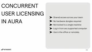
Emesent Ana Özellikler
Emesent Faydaları
Emesent'ı kimler kullanmalı?
Rozetler
Rozetlerimizden biriyle SaaS yetkinizi artırın
Emesent Alternatifleri
WebScraping Terfi Edildi
This AI-powered web scraping solution automates the extraction of data from w...
GeoSpatial Technologies
This technology provides real-time tracking and advanced mapping solutions fo...
Yuneec
This advanced aerial technology is designed for a variety of commercial appli...
Airbox
This advanced mapping technology and software suite enhances situational awar...
Bu kategoride daha fazlasını keşfedin:
Kullanılan Teknolojiler
Weglot
Yeost SEO Plugin
Google Tag Manager
Tailwind
Hubspot
Cloudfront
HTML5
WordPress
Cloudflare
Wix Content Delivery Network (CDN)
Ortaklık Programı
Ortaklık Programı:
Ortaklık Programına Katılın
* Google, güvenli olmayan web kaynakları hakkında doğru ve güncel bilgiler sağlamaya çalışır ancak sonuçların eksiksiz veya hatasız olduğunu garanti edemez.
** Bu sayfanın bazı veya tüm bölümleri yapay zeka tarafından oluşturulmuş olabilir, bu nedenle lütfen kritik bilgileri bağımsız olarak doğrulayın.
Son Zamanlarda Talep Edilenler
Veri Analizi ve Görselleştirme Yazılımı
Çalışan İzleme Yazılımı
Satış Otomasyon Yazılımı
Muhasebe Yazılımı
Yapay Zeka Destekli Video Düzenleme ve Animasyon Araçları
Performans Yönetimi ve Çalışan Değerlendirmeleri
Kalite Yönetim Sistemleri (KYS)
Yapay Zeka Destekli Ürün Öneri Motorları
Müşteri Geri Bildirimi ve Anket Yazılımı
Satış Otomasyon Yazılımı
Son Eklenenler
Visora
BT Varlık Yönetimi Yazılımı
SaarasAI
Finansal Planlama ve Bütçeleme Araçları
Web3 Network Ledger
Blockchain ve NFT Yönetim Platformları
Loss Run Pro
Sigorta Acentesi Yönetimi
MQTTfy
Endüstriyel IoT Platformları
Rucoria
İnşaat Proje Yönetimi Araçları
ViZuTrade
Hisse Senedi Alım Satım ve Aracılık Platformları
CryptoChat
Şifreleme Yazılımı
TryonMirror
Yapay Zeka Destekli Sanal Avatarlar ve Dijital Asistanlar
Anvil HUD
İş Maliyetlendirme Yazılımı
Bu Ayın En İyi 10 Kategorisi
1.
Satış Otomasyon Yazılımı
+856
Son 30 günde bu kategoriye eklenen yeni SaaS ürünlerinin sayısı.
2.
Blockchain ve NFT Yönetim Platformları
+592
Son 30 günde bu kategoriye eklenen yeni SaaS ürünlerinin sayısı.
3.
Belge Yönetimi ve eİmza Araçları
+522
Son 30 günde bu kategoriye eklenen yeni SaaS ürünlerinin sayısı.
4.
Yapay Zeka Destekli Sanal Avatarlar ve Dijital Asistanlar
+497
Son 30 günde bu kategoriye eklenen yeni SaaS ürünlerinin sayısı.
5.
Bulut Güvenliği ve Uyumluluk Araçları
+493
Son 30 günde bu kategoriye eklenen yeni SaaS ürünlerinin sayısı.
6.
Yapay Zeka Destekli Özgeçmiş Tarama Araçları
+489
Son 30 günde bu kategoriye eklenen yeni SaaS ürünlerinin sayısı.
7.
Yapay Zeka Destekli Tanı ve Sağlık Analizi
+445
Son 30 günde bu kategoriye eklenen yeni SaaS ürünlerinin sayısı.
8.
Yapay Zeka Destekli Hukuk Araştırma Platformları
+433
Son 30 günde bu kategoriye eklenen yeni SaaS ürünlerinin sayısı.
9.
Öğrenme ve Eğitim Platformları
+426
Son 30 günde bu kategoriye eklenen yeni SaaS ürünlerinin sayısı.
10.
Filo Yönetim Yazılımı
+422
Son 30 günde bu kategoriye eklenen yeni SaaS ürünlerinin sayısı.
SaaS Tarayıcı İstatistikleri
Son 30 Günde Eklenenler
+21,811
Son 30 günde veritabanımıza eklenen yeni SaaS ürünlerinin sayısı.
Aktif SaaS
468,001
Arama motorumuzda şu anda indekslenmiş olan yayınlanmış ve aktif SaaS ürünlerinin toplam sayısı.
Veritabanındaki Toplam
1,296,182
Veritabanımızdaki tüm SaaS ürünlerinin toplam sayısı, yayınlanmamış ve üretimi durdurulmuş ürünler de dahil.
SaaS Browser'a Ücretsiz Katılın
Tüm gelişmiş filtreleri ücretsiz kullanın.
SaaS ürün listelemelerinizi yönetin
Yeni SaaS ürünleri için ücretsiz uyarılar oluşturun.
Sponsorlu
Replug
İçerik Pazarlama Platformları
Hello Audio
Podcast Barındırma ve Dağıtım Platformları
upcoach
Çevrimiçi Kurs Platformları
Receipt Bot
Yapay Zeka Destekli Belge İşleme
VideoGen
Yapay Zeka Destekli Video Düzenleme ve Animasyon Araçları
Rankability
Metin Yazarlığı ve Yapay Zeka İçerik Üretimi
SimpleBackups
Bulut Depolama, Yedekleme ve Dosya Paylaşımı
REsimpli
Gayrimenkul CRM ve Potansiyel Müşteri Yönetimi
Singing Carrots
Yapay Zeka Destekli Dil Öğrenme Uygulamaları
RankPrompt
Yapay Zeka Destekli Ürün Öneri Motorları
Fırsatı kaçırmayın, ilk siz haberdar olun!
Her gün yeni SaaS ürünleri piyasaya sürülüyor, sadece son 30 günde 21,811 ürün eklendi. Haberdar olun ve SaaS Browser tarafından arama sorgunuza uyan yeni bir SaaS ürünü keşfedildiğinde ilk siz haberdar olun.
Aramanızla eşleşen yeni SaaS için e-posta uyarıları oluşturmak amacıyla giriş yapın.
Uyarı Oluşturmak için Giriş Yap
Benzer araçları keşfedin
Tümünü görüntüle →