Отримати перевірку та оновити профіль
Заявлені профілі відображаються у верхній частині результатів пошуку. Підтвердьте свої профілі зараз, це займе лише кілька хвилин.
Відвідайте
Звіт
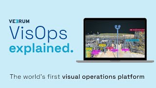
A visual operations platform facilitates the management and collaboration of industrial data by transforming it into an interactive 3D environment, enabling teams to visualize and analyze asset information remotely. Key features include real-time collaboration, geolocation of visual data, and integration with various data sets, addressing challenges such as reducing site visits, enhancing decision-making accuracy, and improving project alignment for industries like oil and gas, mining, and construction.
VEERUM можна знайти в Mapping & Geographic Information Platform (GIS) категорії.
Найбільш схожі продукти на VEERUM:
Знімки екрана
Ще не завантажено жодних знімків екрана. Ви власник цієї компанії?
Завантажте скріншоти.Відео на YouTube
Відео з офіційного каналу YouTube
(20 videos)


Деталі
LinkedIn:
Відвідайте
YouTube:
Відвідайте
Facebook:
Відвідайте
X:
Відвідайте
Рік заснування:
2014
Ціноутворення:
$0/mo
Тип споживача:
B2B
Основні характеристики VEERUM
Переваги VEERUM
Кому варто використовувати VEERUM?
Значки
Підвищте свій авторитет SaaS за допомогою одного з наших значків
Альтернативи VEERUM
Taskade Підвищено
A comprehensive digital platform designed to facilitate the creation, automat...
Aetos
This platform enhances operational efficiency by providing a comprehensive vi...
Optelos
The Visual Inspection Data Management Platform leverages Computer Vision AI t...
Hopara
This platform enables you to build a digital representation of your operation...
Flow Immersive
This innovative platform transforms complex datasets into immersive, interact...
Eye-bot
A remote asset visualization platform blends autonomous drone flights, 3D sca...
Birdi
A collaborative geospatial platform enables teams to seamlessly manage, visua...
Дізнайтеся більше в цій категорії:
Використані технології
Matomo
Awesome Font
WordPress REST API
Gravity Forms
Google Tag Manager
Cloudways
CDNJS
Tailwind
Hubspot
Cookiebot
HTML5
WordPress
Wistia
Cloudflare
Wix Content Delivery Network (CDN)
* Google прагне надавати точну та актуальну інформацію про небезпечні веб-ресурси, але не може гарантувати повноту чи безпомилкові результати.
** Деякі або всі частини цієї сторінки можуть бути створені штучним інтелектом, тому, будь ласка, перевіряйте будь-яку важливу інформацію самостійно.
Нещодавно заявлено
Програмне забезпечення для відстеження часу та продуктивності
Платформи для потокового мовлення та прямих трансляцій
Інструменти хмарної безпеки та відповідності вимогам
Програмне забезпечення для відстеження часу та продуктивності
Програмне забезпечення для управління проектами
Копірайтинг та створення контенту зі штучним інтелектом
Віртуальний тур нерухомістю та 3D-картографування
Веб-безпека та захист від DDoS-атак
Платформи для управління подіями та продажу квитків
Обробка документів на базі штучного інтелекту
Нещодавно додані
TechDeck
Програмне забезпечення для управління проектами
CSS GPT
Підготовка до сертифікації, іспитів та оцінювання
Cortexa
Платформи психічного здоров'я та терапії
IOSefin
Системи точок продажу (POS)
Loopzit
Програмне забезпечення для реферальних програм та програм лояльності
Senu Labs
Програмне забезпечення для служби підтримки клієнтів та служби підтримки
List Perfectly
Брокерські контори та торговельні майданчики
Virality
Програмне забезпечення для автоматизації продажів
Gudtrip
Платформи управління блокчейном та NFT
Connexup
Системи POS та управління ресторанами
10 найкращих категорій цього місяця
1.
Програмне забезпечення для автоматизації продажів
+856
Кількість нових SaaS-продуктів, доданих до цієї категорії за останні 30 днів.
2.
Платформи управління блокчейном та NFT
+592
Кількість нових SaaS-продуктів, доданих до цієї категорії за останні 30 днів.
3.
Інструменти управління документами та електронного підпису
+522
Кількість нових SaaS-продуктів, доданих до цієї категорії за останні 30 днів.
4.
Віртуальні аватари та цифрові помічники на базі штучного інтелекту
+497
Кількість нових SaaS-продуктів, доданих до цієї категорії за останні 30 днів.
5.
Інструменти хмарної безпеки та відповідності вимогам
+493
Кількість нових SaaS-продуктів, доданих до цієї категорії за останні 30 днів.
6.
Інструменти перевірки резюме на базі штучного інтелекту
+489
Кількість нових SaaS-продуктів, доданих до цієї категорії за останні 30 днів.
7.
Діагностика та аналітика охорони здоров'я на базі штучного інтелекту
+445
Кількість нових SaaS-продуктів, доданих до цієї категорії за останні 30 днів.
8.
Платформи юридичних досліджень на базі штучного інтелекту
+433
Кількість нових SaaS-продуктів, доданих до цієї категорії за останні 30 днів.
9.
Навчальні та освітні платформи
+426
Кількість нових SaaS-продуктів, доданих до цієї категорії за останні 30 днів.
10.
Програмне забезпечення для управління автопарком
+422
Кількість нових SaaS-продуктів, доданих до цієї категорії за останні 30 днів.
Статистика браузерів SaaS
Додано за останні 30 днів
+21,811
Кількість нових SaaS-продуктів, виявлених та доданих до нашої бази даних за останні 30 днів.
Активний SaaS
468,001
Загальна кількість опублікованих та активних SaaS-продуктів, що наразі проіндексовані в нашій пошуковій системі.
Загальна сума в базі даних
1,296,182
Загальна кількість усіх SaaS-продуктів у нашій базі даних, включаючи неопубліковані та припинені записи.
Приєднуйтесь до SaaS-браузера безкоштовно
Використовуйте всі розширені фільтри безкоштовно
Керуйте своїми SaaS-оголошеннями
Створюйте безкоштовні сповіщення для нових SaaS
Спонсоровано
WalletCalcs
Інструменти фінансового планування та бюджетування
APITemplate
Обробка документів на базі штучного інтелекту
Nuelink
Управління соціальними мережами та планування
DashThis
Програмне забезпечення для аналізу та візуалізації даних
Taggbox
Платформи контент-маркетингу
Usermaven
Теплові карти веб-сайту та UX-аналіз
TekMatix
Платформи автоматизації маркетингу
4aGoodCause
CRM для управління донорами та фандрейзингу
Taskade
Конструктори додатків без коду на базі штучного інтелекту
Viralsweep
Інструменти SMS-маркетингу та WhatsApp
Не пропустіть, дізнайтеся першими!
Нові продукти SaaS запускаються щодня, лише за останні 30 днів було додано 21,811. Будьте в курсі подій і першими дізнайтеся, коли браузер SaaS виявляє нові продукти SaaS, що відповідають вашому пошуковому запиту.
Увійдіть, щоб налаштувати сповіщення електронною поштою про нові SaaS, що відповідають вашому пошуку.
Увійдіть, щоб створити сповіщення
Перегляньте схожі інструменти
Переглянути всі →