Xác minh và cập nhật hồ sơ
Hồ sơ đã xác minh sẽ được hiển thị đầu kết quả tìm kiếm. Hãy xác minh ngay, chỉ mất vài phút.
Thăm nom
Báo cáo
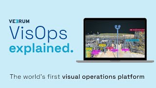
A visual operations platform facilitates the management and collaboration of industrial data by transforming it into an interactive 3D environment, enabling teams to visualize and analyze asset information remotely. Key features include real-time collaboration, geolocation of visual data, and integration with various data sets, addressing challenges such as reducing site visits, enhancing decision-making accuracy, and improving project alignment for industries like oil and gas, mining, and construction.
VEERUM có thể được tìm thấy trong Mapping & Geographic Information Platform (GIS) Thể loại.
Các sản phẩm tương tự nhất với VEERUM là:
Ảnh chụp màn hình
Chưa có ảnh chụp màn hình nào được tải lên. Bạn có sở hữu doanh nghiệp này không?
Tải ảnh chụp màn hình lên.Video YouTube
Video từ kênh YouTube chính thức
(20 videos)


Chi tiết
LinkedIn:
Thăm nom
YouTube:
Thăm nom
Facebook:
Thăm nom
X:
Thăm nom
Năm thành lập:
2014
Giá cả:
$0/mo
Loại người tiêu dùng:
B2B
Đánh giá
–
0 đánh giá
5
–
4
–
3
–
2
–
1
–
Các tính năng chính của VEERUM
VEERUM Lợi ích
Ai nên sử dụng VEERUM?
Huy hiệu
Tăng quyền hạn SaaS của bạn với một trong những huy hiệu của chúng tôi
Các lựa chọn thay thế VEERUM
Taskade Được thăng chức
A comprehensive digital platform designed to facilitate the creation, automat...
Aetos
This platform enhances operational efficiency by providing a comprehensive vi...
Optelos
The Visual Inspection Data Management Platform leverages Computer Vision AI t...
Hopara
This platform enables you to build a digital representation of your operation...
Flow Immersive
This innovative platform transforms complex datasets into immersive, interact...
Eye-bot
A remote asset visualization platform blends autonomous drone flights, 3D sca...
Birdi
A collaborative geospatial platform enables teams to seamlessly manage, visua...
Khám phá thêm trong chuyên mục này:
Công nghệ được sử dụng
Matomo
Awesome Font
WordPress REST API
Gravity Forms
Google Tag Manager
Cloudways
CDNJS
Tailwind
Hubspot
Cookiebot
HTML5
WordPress
Wistia
Cloudflare
Wix Content Delivery Network (CDN)
* Google cố gắng cung cấp thông tin chính xác và cập nhật về các nguồn web không an toàn nhưng không thể đảm bảo tính đầy đủ hoặc kết quả không có lỗi.
** Một số hoặc toàn bộ trang này có thể được tạo ra bằng AI, vì vậy vui lòng tự xác minh mọi thông tin quan trọng.
Mới được yêu cầu
Công cụ SEO
Ứng dụng ghi chú kỹ thuật số
Phần mềm phân tích và trực quan hóa dữ liệu
Phần mềm khảo sát và phản hồi khách hàng
Phần mềm tạo khách hàng tiềm năng
Phần mềm khảo sát và phản hồi khách hàng
Viết và tạo bản sao được hỗ trợ bởi AI
Phần mềm khảo sát và phản hồi khách hàng
Nền tảng nghiên cứu pháp lý hỗ trợ AI
Phần mềm theo dõi thời gian và năng suất
Mới thêm gần đây
KitQuest
Ứng dụng quản lý tác vụ và danh sách việc cần làm
Fabbi
Phần mềm quản lý tiền lương
Hisab Nikas
Phần mềm kế toán
MIRRA
Nền tảng giao dịch và môi giới chứng khoán
Tonada
Âm thanh và Âm nhạc
cointoku
Sàn giao dịch tiền điện tử
EazyTagg
Nền tảng quản lý sự kiện và bán vé
LevelCheck
Công cụ sàng lọc sơ yếu lý lịch hỗ trợ AI
XFRAME
Phần mềm tiếp thị sự kiện
DrivOQ
Hệ thống quản lý vận tải (TMS)
10 hạng mục hàng đầu tháng này
1.
Phần mềm tự động hóa bán hàng
+856
Số lượng sản phẩm SaaS mới được thêm vào danh mục này trong 30 ngày qua.
2.
Nền tảng quản lý Blockchain & NFT
+592
Số lượng sản phẩm SaaS mới được thêm vào danh mục này trong 30 ngày qua.
3.
Công cụ quản lý tài liệu và chữ ký điện tử
+522
Số lượng sản phẩm SaaS mới được thêm vào danh mục này trong 30 ngày qua.
4.
Avatar ảo và trợ lý kỹ thuật số được hỗ trợ bởi AI
+497
Số lượng sản phẩm SaaS mới được thêm vào danh mục này trong 30 ngày qua.
5.
Công cụ bảo mật và tuân thủ đám mây
+493
Số lượng sản phẩm SaaS mới được thêm vào danh mục này trong 30 ngày qua.
6.
Công cụ sàng lọc sơ yếu lý lịch hỗ trợ AI
+489
Số lượng sản phẩm SaaS mới được thêm vào danh mục này trong 30 ngày qua.
7.
Chẩn đoán và phân tích chăm sóc sức khỏe bằng AI
+445
Số lượng sản phẩm SaaS mới được thêm vào danh mục này trong 30 ngày qua.
8.
Nền tảng nghiên cứu pháp lý hỗ trợ AI
+433
Số lượng sản phẩm SaaS mới được thêm vào danh mục này trong 30 ngày qua.
9.
Nền tảng học tập và giáo dục
+426
Số lượng sản phẩm SaaS mới được thêm vào danh mục này trong 30 ngày qua.
10.
Phần mềm quản lý đội xe
+422
Số lượng sản phẩm SaaS mới được thêm vào danh mục này trong 30 ngày qua.
Thống kê trình duyệt SaaS
Đã thêm trong 30 ngày qua
+21,811
Số lượng sản phẩm SaaS mới được phát hiện và thêm vào cơ sở dữ liệu của chúng tôi trong 30 ngày qua.
Phần mềm dịch vụ chủ động (Active SaaS)
468,001
Tổng số sản phẩm SaaS đã được xuất bản và đang hoạt động hiện được lập chỉ mục trong công cụ tìm kiếm của chúng tôi.
Tổng số trong cơ sở dữ liệu
1,296,182
Tổng số lượng tất cả các sản phẩm SaaS trong cơ sở dữ liệu của chúng tôi, bao gồm cả các sản phẩm chưa được công bố và đã ngừng hoạt động.
Tham gia SaaS Browser miễn phí
Sử dụng tất cả các bộ lọc nâng cao miễn phí
Quản lý danh sách phần mềm dưới dạng dịch vụ (SaaS) của bạn
Tạo thông báo miễn phí về các phần mềm SaaS mới.
Được tài trợ
Mailshake
Nền tảng tự động hóa tiếp thị
LatePoint
Phần mềm đặt lịch hẹn
Pixpa
Người xây dựng trang web
Xtensio
Nền tảng tiếp thị nội dung
Fraud Blocker
Chặn quảng cáo & Quyền riêng tư
Clerk Chat
Công cụ tiếp thị đàm thoại và Chatbot
Collect.chat
Công cụ tiếp thị đàm thoại và Chatbot
SmartTask
Quản lý công việc từ xa và theo dõi năng suất
ReciPal
SaaS lập kế hoạch dinh dưỡng và chế độ ăn uống
GlockApps
Phần mềm tiếp thị qua email
Đừng bỏ lỡ, hãy là người đầu tiên biết tin!
Mỗi ngày đều có các sản phẩm SaaS mới ra mắt, riêng trong 30 ngày qua đã có thêm 21,811 sản phẩm mới. Hãy luôn cập nhật thông tin và là người đầu tiên biết khi SaaS Browser phát hiện ra sản phẩm SaaS mới phù hợp với truy vấn tìm kiếm của bạn.
Đăng nhập để thiết lập cảnh báo qua email cho các SaaS mới phù hợp với tìm kiếm của bạn.
Đăng nhập để tạo cảnh báo
Khám phá các công cụ tương tự
Xem tất cả →