Få bekræftet og opdater profil
Profiler, der er gjort krav på, vises øverst i søgeresultaterne. Bliv bekræftet nu, det tager kun et par minutter.
Besøg
Rapport
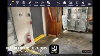
This three-dimensional scanning application provides precise control over accuracy, enabling detailed and extensive capture of large-scale scenes such as buildings, roadways, and infrastructure. Its key features include automatic optimization algorithms for post-processing, seamless integration with high-precision GNSS devices for geo-referencing, support for adding coded targets and reference measurements to improve accuracy, and the ability to handle virtually unlimited scene sizes with rapid local processing and compatibility with desktop data editing—making it ideal for professionals in architecture, surveying, construction, and engineering seeking efficient, reliable, and scalable 3D data acquisition and analysis.
Dot3D kan findes i Architectural Design & Drafting Software kategorier.
De produkter, der ligner Dot3D mest, er:
Skærmbilleder
Der er endnu ikke uploadet nogen skærmbilleder. Ejer du denne virksomhed?
Upload skærmbilleder.YouTube-videoer
Videoer fra den officielle YouTube-kanal
(2 videos)

Detaljer
LinkedIn:
Besøg
YouTube:
Besøg
Facebook:
Besøg
X:
Besøg
Instagram:
Besøg
År etableret:
2012
Priser:
$0-$999/mo
Forbrugertype:
B2B
Dot3D Hovedfunktioner
Badges
Øg din SaaS-autoritet med et af vores badges
Dot3D Alternativer
Contractor Foreman Forfremmet
This comprehensive construction management platform streamlines the coordinat...
Pythagoras
This software suite provides comprehensive tools for surveying, mapping, cons...
3Dsurvey
This comprehensive software solution specializes in photogrammetry, mapping, ...
Carlson
This comprehensive land surveying and civil engineering software suite offers...
NUBIGON
This software facilitates the visualization, analysis, and presentation of co...
Undet
This software suite offers advanced tools for converting, visualizing, and an...
Ajile
This advanced 3D imaging and measurement system leverages high-resolution, fu...
RecFusion
This system enables real-time 3D digitization and modeling using RGB-D sensor...
SkyeBrowse
This innovative software transforms video footage into detailed 3D models, en...
Udforsk mere i denne kategori:
Anvendte teknologier
Squarespace
reCAPTCHA
MailChimp
Zoho
Adobe Fonts
Google Tag Manager
Tailwind
HTML5
Angular
WordPress
Wix Content Delivery Network (CDN)
Partnerprogram
Partnerprogram:
Tilmeld dig affiliateprogrammet
* Google bestræber sig på at levere nøjagtige og opdaterede oplysninger om usikre webressourcer, men kan ikke garantere fuldstændighed eller fejlfri resultater.
** Nogle eller alle dele af denne side kan være genereret af kunstig intelligens, så verificér venligst alle kritiske oplysninger uafhængigt.
Nyligt gjort krav på
Kontakthåndteringssoftware
Fakturering og betalingsbehandling
Administration og planlægning af sociale medier
Administration og planlægning af sociale medier
CRM (kunderelationsstyring)
Tidsregistrering og produktivitetssoftware
Krypto
Tidsregistrering og produktivitetssoftware
AI-drevet skrivning og kopigenerering
Flådestyringssoftware
Nyligt tilføjet
REENG
Software til aftaleplanlægning
Velnai
SMS- og WhatsApp-marketingværktøjer
SalesCRM
Salgsautomatiseringssoftware
GrieveTrac
Klage- og sagsbehandling
RustIQ
Discord- og Telegram-fællesskabsværktøjer
Senu Labs
Helpdesk- og kundesupportsoftware
Tropic
Streaming- og live-udsendelsesplatforme
Equilly
Software til compliance-styring
GRAHAs VR Spaces
Digitale adoptionsplatforme
EazyStats
Produktanalysesoftware
Top 10 kategorier denne måned
1.
Salgsautomatiseringssoftware
+856
Antal nye SaaS-produkter tilføjet til denne kategori i de seneste 30 dage.
2.
Blockchain- og NFT-administrationsplatforme
+592
Antal nye SaaS-produkter tilføjet til denne kategori i de seneste 30 dage.
3.
Dokumenthåndtering og e-signaturværktøjer
+522
Antal nye SaaS-produkter tilføjet til denne kategori i de seneste 30 dage.
4.
AI-drevne virtuelle avatarer og digitale assistenter
+497
Antal nye SaaS-produkter tilføjet til denne kategori i de seneste 30 dage.
5.
Værktøjer til cloudsikkerhed og compliance
+493
Antal nye SaaS-produkter tilføjet til denne kategori i de seneste 30 dage.
6.
AI-drevne CV-screeningsværktøjer
+489
Antal nye SaaS-produkter tilføjet til denne kategori i de seneste 30 dage.
7.
AI-drevet diagnose og sundhedsanalyse
+445
Antal nye SaaS-produkter tilføjet til denne kategori i de seneste 30 dage.
8.
AI-drevne juridiske forskningsplatforme
+433
Antal nye SaaS-produkter tilføjet til denne kategori i de seneste 30 dage.
9.
Lærings- og uddannelsesplatforme
+426
Antal nye SaaS-produkter tilføjet til denne kategori i de seneste 30 dage.
10.
Flådestyringssoftware
+422
Antal nye SaaS-produkter tilføjet til denne kategori i de seneste 30 dage.
SaaS-browserstatistik
Tilføjet de seneste 30 dage
+21,811
Antal nye SaaS-produkter opdaget og tilføjet til vores database i de sidste 30 dage.
Aktiv SaaS
468,001
Samlet antal publicerede og aktive SaaS-produkter, der i øjeblikket er indekseret i vores søgemaskine.
Total i databasen
1,296,182
Samlet antal af alle SaaS-produkter i vores database, inklusive ikke-publicerede og udgåede poster.
Tilmeld dig SaaS Browser gratis
Brug alle avancerede filtre gratis
Administrer dine SaaS-lister
Opret gratis alarmer til nye SaaS-løsninger
Sponsoreret
VideoGen
AI-drevne videoredigerings- og animationsværktøjer
Snaptually
AI-drevne virtuelle avatarer og digitale assistenter
Click Analytic
Influencer Marketing & Outreach-værktøjer
SendShort
AI-drevne videoredigerings- og animationsværktøjer
Draftbit
AI-drevne appbyggere uden kode
Fish Audio
Stemmekloning og tekst-til-tale SaaS
Sniply
SMS- og WhatsApp-marketingværktøjer
REsimpli
CRM og leadhåndtering i fast ejendom
BookingPress
Software til aftaleplanlægning
Pristan.chat
API- og backend-as-a-service-platforme
Gå ikke glip af det, vær den første til at vide det!
Nye SaaS-produkter lanceres hver dag, 21,811 er blevet tilføjet alene i de sidste 30 dage. Hold dig informeret, og vær den første til at vide, når SaaS Browser opdager nye SaaS-produkter, der matcher din søgeforespørgsel.
Log ind for at opsætte e-mailalarmer for nye SaaS, der matcher din søgning.
Log ind for at oprette alarm
Udforsk lignende værktøjer
Gennemse alle →