Få bekræftet og opdater profil
Profiler, der er gjort krav på, vises øverst i søgeresultaterne. Bliv bekræftet nu, det tager kun et par minutter.
Besøg
Rapport
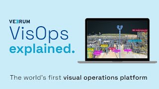
A visual operations platform facilitates the management and collaboration of industrial data by transforming it into an interactive 3D environment, enabling teams to visualize and analyze asset information remotely. Key features include real-time collaboration, geolocation of visual data, and integration with various data sets, addressing challenges such as reducing site visits, enhancing decision-making accuracy, and improving project alignment for industries like oil and gas, mining, and construction.
VEERUM kan findes i Mapping & Geographic Information Platform (GIS) kategorier.
De produkter, der ligner VEERUM mest, er:
Skærmbilleder
Der er endnu ikke uploadet nogen skærmbilleder. Ejer du denne virksomhed?
Upload skærmbilleder.YouTube-videoer
Videoer fra den officielle YouTube-kanal
(20 videos)


Detaljer
LinkedIn:
Besøg
YouTube:
Besøg
Facebook:
Besøg
X:
Besøg
År etableret:
2014
Priser:
$0/mo
Forbrugertype:
B2B
VEERUM Hovedfunktioner
VEERUM fordele
Hvem bør bruge VEERUM?
Badges
Øg din SaaS-autoritet med et af vores badges
VEERUM Alternativer
Taskade Forfremmet
A comprehensive digital platform designed to facilitate the creation, automat...
Aetos
This platform enhances operational efficiency by providing a comprehensive vi...
Optelos
The Visual Inspection Data Management Platform leverages Computer Vision AI t...
Hopara
This platform enables you to build a digital representation of your operation...
Flow Immersive
This innovative platform transforms complex datasets into immersive, interact...
Eye-bot
A remote asset visualization platform blends autonomous drone flights, 3D sca...
Birdi
A collaborative geospatial platform enables teams to seamlessly manage, visua...
Udforsk mere i denne kategori:
Anvendte teknologier
Matomo
Awesome Font
WordPress REST API
Gravity Forms
Google Tag Manager
Cloudways
CDNJS
Tailwind
Hubspot
Cookiebot
HTML5
WordPress
Wistia
Cloudflare
Wix Content Delivery Network (CDN)
* Google bestræber sig på at levere nøjagtige og opdaterede oplysninger om usikre webressourcer, men kan ikke garantere fuldstændighed eller fejlfri resultater.
** Nogle eller alle dele af denne side kan være genereret af kunstig intelligens, så verificér venligst alle kritiske oplysninger uafhængigt.
Nyligt gjort krav på
Lyd og musik
AI-drevne CV-screeningsværktøjer
Lærings- og uddannelsesplatforme
Værktøjer til cloudsikkerhed og compliance
Flådestyringssoftware
Kundefeedback- og spørgeskemasoftware
Shopify-apps
AI-drevne juridiske forskningsplatforme
Kundefeedback- og spørgeskemasoftware
AI-drevne CV-screeningsværktøjer
Nyligt tilføjet
Clanker
Kollektiv intelligensplatform
IJEM
Løsninger til levering i sidste mil
RustIQ
Discord- og Telegram-fællesskabsværktøjer
PrintPro
Print-on-Demand automatiseringssoftware
Primer Pages
Versionskontrol og Git-hosting
REENG
Software til aftaleplanlægning
Virality
Salgsautomatiseringssoftware
Staritas
Software til forsyningskædestyring (SCM)
Computer Planet
AI-drevet diagnose og sundhedsanalyse
Veoora
Online madbestilling og levering
Top 10 kategorier denne måned
1.
Salgsautomatiseringssoftware
+856
Antal nye SaaS-produkter tilføjet til denne kategori i de seneste 30 dage.
2.
Blockchain- og NFT-administrationsplatforme
+592
Antal nye SaaS-produkter tilføjet til denne kategori i de seneste 30 dage.
3.
Dokumenthåndtering og e-signaturværktøjer
+522
Antal nye SaaS-produkter tilføjet til denne kategori i de seneste 30 dage.
4.
AI-drevne virtuelle avatarer og digitale assistenter
+497
Antal nye SaaS-produkter tilføjet til denne kategori i de seneste 30 dage.
5.
Værktøjer til cloudsikkerhed og compliance
+493
Antal nye SaaS-produkter tilføjet til denne kategori i de seneste 30 dage.
6.
AI-drevne CV-screeningsværktøjer
+489
Antal nye SaaS-produkter tilføjet til denne kategori i de seneste 30 dage.
7.
AI-drevet diagnose og sundhedsanalyse
+445
Antal nye SaaS-produkter tilføjet til denne kategori i de seneste 30 dage.
8.
AI-drevne juridiske forskningsplatforme
+433
Antal nye SaaS-produkter tilføjet til denne kategori i de seneste 30 dage.
9.
Lærings- og uddannelsesplatforme
+426
Antal nye SaaS-produkter tilføjet til denne kategori i de seneste 30 dage.
10.
Flådestyringssoftware
+422
Antal nye SaaS-produkter tilføjet til denne kategori i de seneste 30 dage.
SaaS-browserstatistik
Tilføjet de seneste 30 dage
+21,811
Antal nye SaaS-produkter opdaget og tilføjet til vores database i de sidste 30 dage.
Aktiv SaaS
468,001
Samlet antal publicerede og aktive SaaS-produkter, der i øjeblikket er indekseret i vores søgemaskine.
Total i databasen
1,296,182
Samlet antal af alle SaaS-produkter i vores database, inklusive ikke-publicerede og udgåede poster.
Tilmeld dig SaaS Browser gratis
Brug alle avancerede filtre gratis
Administrer dine SaaS-lister
Opret gratis alarmer til nye SaaS-løsninger
Sponsoreret
Devi
Leadgenereringssoftware
Sertifier
Certificerings-, eksamens- og vurderingsforberedelse
Sniply
SMS- og WhatsApp-marketingværktøjer
ProxyCove
Webscraping API og proxyer
StreamYard
Streaming- og live-udsendelsesplatforme
Clerk Chat
Chatbot- og samtalemarkedsføringsværktøjer
LaunchCut
A/B-testning og CRO
OutOnSite
Software til onboarding og træning af medarbejdere
ClearCRM
CRM (kunderelationsstyring)
Accessibly
Hjemmesidebyggere
Gå ikke glip af det, vær den første til at vide det!
Nye SaaS-produkter lanceres hver dag, 21,811 er blevet tilføjet alene i de sidste 30 dage. Hold dig informeret, og vær den første til at vide, når SaaS Browser opdager nye SaaS-produkter, der matcher din søgeforespørgsel.
Log ind for at opsætte e-mailalarmer for nye SaaS, der matcher din søgning.
Log ind for at oprette alarm
Udforsk lignende værktøjer
Gennemse alle →