تأیید شوید و نمایه را بهروزرسانی کنید
پروفایلهای ثبتشده به بالای نتایج جستجو میروند. همین حالا تأیید شوید، فقط چند دقیقه طول میکشد.
بازدید
گزارش
This three-dimensional scanning application provides precise control over accuracy, enabling detailed and extensive capture of large-scale scenes such as buildings, roadways, and infrastructure. Its key features include automatic optimization algorithms for post-processing, seamless integration with high-precision GNSS devices for geo-referencing, support for adding coded targets and reference measurements to improve accuracy, and the ability to handle virtually unlimited scene sizes with rapid local processing and compatibility with desktop data editing—making it ideal for professionals in architecture, surveying, construction, and engineering seeking efficient, reliable, and scalable 3D data acquisition and analysis.
Dot3D را میتوان در موارد زیر یافت: Architectural Design & Drafting Software دسته بندی ها.
شبیهترین محصولات به Dot3D عبارتند از:
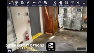
اسکرینشاتها
هنوز هیچ اسکرینشاتی آپلود نشده است. آیا شما صاحب این کسب و کار هستید؟
اسکرینشاتها را آپلود کنید.ویدیوهای یوتیوب
ویدیوها از کانال رسمی یوتیوب
(2 videos)

جزئیات
LinkedIn:
بازدید
YouTube:
بازدید
Facebook:
بازدید
X:
بازدید
Instagram:
بازدید
سال تأسیس:
2012
قیمتگذاری:
$0-$999/mo
نوع مصرف کننده:
B2B
نقد و بررسیها
–
0 نقد و بررسیها
5
–
4
–
3
–
2
–
1
–
Dot3D ویژگیهای اصلی
نشانها
با یکی از نشانهای ما، اعتبار SaaS خود را افزایش دهید
Dot3D جایگزین
Contractor Foreman تبلیغ شده
This comprehensive construction management platform streamlines the coordinat...
Pythagoras
This software suite provides comprehensive tools for surveying, mapping, cons...
3Dsurvey
This comprehensive software solution specializes in photogrammetry, mapping, ...
Carlson
This comprehensive land surveying and civil engineering software suite offers...
NUBIGON
This software facilitates the visualization, analysis, and presentation of co...
Undet
This software suite offers advanced tools for converting, visualizing, and an...
Ajile
This advanced 3D imaging and measurement system leverages high-resolution, fu...
RecFusion
This system enables real-time 3D digitization and modeling using RGB-D sensor...
SkyeBrowse
This innovative software transforms video footage into detailed 3D models, en...
کاوش بیشتر در این دسته بندی:
فناوریهای مورد استفاده
Squarespace
reCAPTCHA
MailChimp
Zoho
Adobe Fonts
Google Tag Manager
Tailwind
HTML5
Angular
WordPress
Wix Content Delivery Network (CDN)
برنامه همکاری در فروش
برنامه همکاری در فروش:
به برنامه همکاری در فروش بپیوندید
* گوگل تلاش میکند تا اطلاعات دقیق و بهروزی در مورد منابع وب ناامن ارائه دهد، اما نمیتواند کامل بودن یا بدون خطا بودن نتایج را تضمین کند.
** ممکن است برخی یا تمام بخشهای این صفحه توسط هوش مصنوعی تولید شده باشند، بنابراین لطفاً هرگونه اطلاعات مهم را بهطور مستقل تأیید کنید.
اخیراً ادعا شده است
ابزارهای اطلاعرسانی ایمیلی و ایمیلهای سرد
نرمافزار برنامهریزی قرار ملاقات
مدیریت و بهینه سازی میزبانی وب
اپلیکیشنهای آموزش زبان مبتنی بر هوش مصنوعی
نرمافزار حسابداری
نرمافزار تخمین و مناقصه ساختوساز
نرمافزار اتوماسیون فروش
پلتفرمهای یادگیری و آموزش
صورتحساب اشتراک و پرداختهای دورهای
صدور فاکتور و پردازش پرداخت
اخیراً اضافه شده است
PrepNiz
پلتفرمهای یادگیری و آموزش
Sports Management
پلتفرمهای مدیریت رویداد و فروش بلیط
FastPix
پلتفرمهای پخش زنده و استریمینگ
CarHubster
کارگزاریها و بازارها
Geneva
نرمافزار پیشبینی و برنامهریزی تقاضا
BrowserBox
پشتیبانی از مرور همزمان و اشتراکگذاری صفحه نمایش
XFRAME
نرمافزار بازاریابی رویداد
WealthForge
ابزارهای برنامهریزی و بودجهبندی مالی
Influbee
ابزارهای ویرایش ویدیو و انیمیشن مبتنی بر هوش مصنوعی
RoverPass
مدیریت اردوگاه و پارک RV
10 دسته برتر این ماه
1.
نرمافزار اتوماسیون فروش
+856
تعداد محصولات جدید SaaS که در 30 روز گذشته به این دسته اضافه شدهاند.
2.
پلتفرمهای مدیریت بلاکچین و NFT
+592
تعداد محصولات جدید SaaS که در 30 روز گذشته به این دسته اضافه شدهاند.
3.
ابزارهای مدیریت اسناد و امضای الکترونیکی
+522
تعداد محصولات جدید SaaS که در 30 روز گذشته به این دسته اضافه شدهاند.
4.
آواتارهای مجازی و دستیاران دیجیتال مجهز به هوش مصنوعی
+497
تعداد محصولات جدید SaaS که در 30 روز گذشته به این دسته اضافه شدهاند.
5.
ابزارهای امنیت و انطباق ابری
+493
تعداد محصولات جدید SaaS که در 30 روز گذشته به این دسته اضافه شدهاند.
6.
ابزارهای غربالگری رزومه مبتنی بر هوش مصنوعی
+489
تعداد محصولات جدید SaaS که در 30 روز گذشته به این دسته اضافه شدهاند.
7.
تشخیص و تحلیل مراقبتهای بهداشتی مبتنی بر هوش مصنوعی
+445
تعداد محصولات جدید SaaS که در 30 روز گذشته به این دسته اضافه شدهاند.
8.
پلتفرمهای تحقیقات حقوقی مبتنی بر هوش مصنوعی
+433
تعداد محصولات جدید SaaS که در 30 روز گذشته به این دسته اضافه شدهاند.
9.
پلتفرمهای یادگیری و آموزش
+426
تعداد محصولات جدید SaaS که در 30 روز گذشته به این دسته اضافه شدهاند.
10.
نرمافزار مدیریت ناوگان
+422
تعداد محصولات جدید SaaS که در 30 روز گذشته به این دسته اضافه شدهاند.
آمار مرورگر SaaS
اضافه شده در 30 روز گذشته
+21,811
تعداد محصولات جدید SaaS که در 30 روز گذشته کشف و به پایگاه داده ما اضافه شدهاند.
SaaS فعال
468,001
تعداد کل محصولات SaaS منتشر شده و فعال که در حال حاضر در موتور جستجوی ما فهرست بندی شده اند.
مجموع در پایگاه داده
1,296,182
تعداد کل محصولات SaaS موجود در پایگاه داده ما، شامل موارد منتشر نشده و متوقف شده.
به صورت رایگان به مرورگر SaaS بپیوندید
از تمام فیلترهای پیشرفته به صورت رایگان استفاده کنید
فهرستهای SaaS خود را مدیریت کنید
ایجاد هشدارهای رایگان برای SaaS جدید
حمایتشده
Sniply
ابزارهای بازاریابی پیامکی و واتساپ
Taskade
سازندگان اپلیکیشن بدون کد با هوش مصنوعی
Xtensio
پلتفرمهای بازاریابی محتوا
Clerk Chat
ابزارهای چتبات و بازاریابی مکالمهای
OutOnSite
نرمافزار آموزش و جذب کارکنان
SellerSonar
ابزارهای آمازون FBA
TekMatix
پلتفرمهای اتوماسیون بازاریابی
BookingPress
نرمافزار برنامهریزی قرار ملاقات
Pristan.chat
پلتفرمهای API و Backend-as-a-Service
SendX
نرمافزار بازاریابی ایمیلی
از دست ندهید، اولین نفری باشید که مطلع میشود!
محصولات جدید SaaS هر روز عرضه میشوند، 21,811 فقط در 30 روز گذشته اضافه شده است. آگاه باشید و اولین نفری باشید که از کشف SaaS جدید مطابق با عبارت جستجوی شما توسط مرورگر SaaS مطلع میشود.
برای تنظیم هشدارهای ایمیلی برای SaaS جدید مطابق با جستجوی خود وارد شوید.
برای ایجاد هشدار وارد شوید
ابزارهای مشابه را بررسی کنید
مرور همه →