Vahvista ja päivitä profiili
Vahvistetut profiilit näkyvät hakutulosten kärjessä. Vahvista profiilisi nyt, se vie vain muutaman minuutin.
Vierailla
Raportti
This three-dimensional scanning application provides precise control over accuracy, enabling detailed and extensive capture of large-scale scenes such as buildings, roadways, and infrastructure. Its key features include automatic optimization algorithms for post-processing, seamless integration with high-precision GNSS devices for geo-referencing, support for adding coded targets and reference measurements to improve accuracy, and the ability to handle virtually unlimited scene sizes with rapid local processing and compatibility with desktop data editing—making it ideal for professionals in architecture, surveying, construction, and engineering seeking efficient, reliable, and scalable 3D data acquisition and analysis.
Dot3D löytyy kohdasta Architectural Design & Drafting Software luokat.
Dot3D:n kaltaisimmat tuotteet ovat:
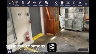
Kuvakaappaukset
Kuvakaappauksia ei ole vielä ladattu. Omistatko tämän yrityksen?
Lataa kuvakaappauksia.YouTube-videot
Videoita viralliselta YouTube-kanavalta
(2 videos)

Tiedot
LinkedIn:
Vierailla
YouTube:
Vierailla
Facebook:
Vierailla
X:
Vierailla
Instagram:
Vierailla
Perustettu vuosi:
2012
Hinnoittelu:
$0-$999/mo
Kuluttajatyyppi:
B2B
Dot3D Pääominaisuudet
Merkit
Lisää SaaS-auktoriteettiasi yhdellä ansiomerkeistämme
Dot3D Vaihtoehtoja
Contractor Foreman Ylennetty
This comprehensive construction management platform streamlines the coordinat...
Pythagoras
This software suite provides comprehensive tools for surveying, mapping, cons...
3Dsurvey
This comprehensive software solution specializes in photogrammetry, mapping, ...
Carlson
This comprehensive land surveying and civil engineering software suite offers...
NUBIGON
This software facilitates the visualization, analysis, and presentation of co...
Undet
This software suite offers advanced tools for converting, visualizing, and an...
Ajile
This advanced 3D imaging and measurement system leverages high-resolution, fu...
RecFusion
This system enables real-time 3D digitization and modeling using RGB-D sensor...
SkyeBrowse
This innovative software transforms video footage into detailed 3D models, en...
Tutustu lisää tässä kategoriassa:
Käytetyt teknologiat
Squarespace
reCAPTCHA
MailChimp
Zoho
Adobe Fonts
Google Tag Manager
Tailwind
HTML5
Angular
WordPress
Wix Content Delivery Network (CDN)
Kumppanuusohjelma
Kumppanuusohjelma:
Liity kumppanuusohjelmaan
* Google pyrkii tarjoamaan tarkkaa ja ajantasaista tietoa vaarallisista verkkoresursseista, mutta ei voi taata täydellisyyttä tai virheettömiä tuloksia.
** Jotkin tai kaikki tämän sivun osat voivat olla tekoälyn luomia, joten tarkista kaikki tärkeät tiedot erikseen.
Äskettäin vaadittu
SEO-työkalut
Etätyön hallinta ja tuottavuuden seuranta
Projektinhallintaohjelmisto
Rakennusprojektien hallintatyökalut
Ajanseuranta- ja tuottavuusohjelmisto
Palkanlaskentaohjelmisto
Suoratoisto- ja live-lähetysalustat
Markkinoinnin automaatioalustat
Myynnin automaatio-ohjelmisto
Tekoälyllä toimiva kirjoittaminen ja tekstin luominen
Äskettäin lisätyt
EazyCart
Välitysliikkeet ja markkinapaikat
Life Manager Pro
Tehtävänhallinta- ja tehtävälistasovellukset
Meetara
Tekoälykokousavustajat ja muistiinpanojen tekijät
Bistroo
Ruoan tilaaminen ja toimitus verkossa
RCS Analytics
AutoML-alustat
Gazellia
Työnkulun automatisointi ja RPA
Daleamedu
Koulun hallintaohjelmisto
DenoShop
Välitysliikkeet ja markkinapaikat
Repurcha
CRM (asiakkuudenhallinta)
Lynette Ventures
Fantasiaurheilu- ja vedonlyöntialustat
Tämän kuun 10 parasta kategoriaa
1.
Myynnin automaatio-ohjelmisto
+856
Tähän kategoriaan viimeisten 30 päivän aikana lisättyjen uusien SaaS-tuotteiden määrä.
2.
Lohkoketju- ja NFT-hallinta-alustat
+592
Tähän kategoriaan viimeisten 30 päivän aikana lisättyjen uusien SaaS-tuotteiden määrä.
3.
Asiakirjojen hallinta- ja sähköisen allekirjoituksen työkalut
+522
Tähän kategoriaan viimeisten 30 päivän aikana lisättyjen uusien SaaS-tuotteiden määrä.
4.
Tekoälyllä toimivat virtuaaliavatarit ja digitaaliset avustajat
+497
Tähän kategoriaan viimeisten 30 päivän aikana lisättyjen uusien SaaS-tuotteiden määrä.
5.
Pilvipalveluiden tietoturva- ja vaatimustenmukaisuustyökalut
+493
Tähän kategoriaan viimeisten 30 päivän aikana lisättyjen uusien SaaS-tuotteiden määrä.
6.
Tekoälyllä toimivat ansioluetteloiden seulontatyökalut
+489
Tähän kategoriaan viimeisten 30 päivän aikana lisättyjen uusien SaaS-tuotteiden määrä.
7.
Tekoälypohjainen diagnoosi ja terveydenhuollon analytiikka
+445
Tähän kategoriaan viimeisten 30 päivän aikana lisättyjen uusien SaaS-tuotteiden määrä.
8.
Tekoälyllä toimivat oikeudelliset tutkimusalustat
+433
Tähän kategoriaan viimeisten 30 päivän aikana lisättyjen uusien SaaS-tuotteiden määrä.
9.
Oppimis- ja koulutusalustat
+426
Tähän kategoriaan viimeisten 30 päivän aikana lisättyjen uusien SaaS-tuotteiden määrä.
10.
Kalustonhallintaohjelmisto
+422
Tähän kategoriaan viimeisten 30 päivän aikana lisättyjen uusien SaaS-tuotteiden määrä.
SaaS-selaimen tilastot
Lisätty viimeisten 30 päivän aikana
+21,811
Viimeisen 30 päivän aikana tietokantaamme löydettyjen ja lisättyjen uusien SaaS-tuotteiden määrä.
Aktiivinen SaaS
468,001
Hakukoneessamme tällä hetkellä indeksoitujen julkaistujen ja aktiivisten SaaS-tuotteiden kokonaismäärä.
Yhteensä tietokannassa
1,296,182
Kaikkien SaaS-tuotteiden kokonaismäärä tietokannassamme, mukaan lukien julkaisemattomat ja lopetetut merkinnät.
Liity SaaS-selaimeen ilmaiseksi
Käytä kaikkia edistyneitä suodattimia ilmaiseksi
Hallinnoi SaaS-listauksiasi
Luo ilmaisia hälytyksiä uusille SaaS-palveluille
Sponsoroitu
Xtensio
Sisältömarkkinointialustat
FullCertified
Sertifiointi-, tentti- ja arviointivalmennus
Contractor Foreman
Rakennusprojektien hallintatyökalut
AnswerThis
Akateemiset työkalut
SocialGlow
Etätiimin yhteistyötyökalut
Draftbit
Tekoälypohjaiset koodittomat sovellusten rakentajat
Nimbata
Yhteystietojen hallintaohjelmisto
RentEase Uganda
Vuokrakiinteistöjen hallinta
Oh Dear
Verkkosivuston valvonta, käyttöaika ja suorituskyky
GlockApps
Sähköpostimarkkinointiohjelmisto
Älä missaa, ole ensimmäisten joukossa, jotka saavat tietää!
Uusia SaaS-tuotteita julkaistaan joka päivä, 21,811 lisättyä pelkästään viimeisen 30 päivän aikana. Pysy ajan tasalla ja ole ensimmäinen, joka tietää, kun SaaS Browser löytää uusia SaaS-tuotteita, jotka vastaavat hakukyselyäsi.
Kirjaudu sisään asettaaksesi sähköposti-ilmoitukset hakuasi vastaavista uusista SaaS-palveluista.
Kirjaudu sisään luodaksesi hälytyksen
Tutustu samankaltaisiin työkaluihin
Selaa kaikkia →