Emesent
マッピングと地理情報プラットフォーム(GIS)This advanced technology enables precise mapping and data capture in challenging environments, enhancing operational efficiency and safety. Key features include autonomous LiDAR mapping, versatile accessory integration, and real-time data processing, addressing issues such as hazardous site assessments and GPS-denied areas, making it ideal for industries like mining, construction, and public safety.
Emesentは次の場所にあります Mapping & Geographic Information Platform (GIS) カテゴリー。
Emesent に最も類似した製品は次のとおりです。
スクリーンショット
スクリーンショットはまだアップロードされていません。このビジネスのオーナーですか?
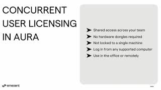
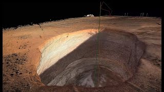
スクリーンショットをアップロードします。YouTube動画
公式YouTubeチャンネルの動画
(20 videos)


詳細
Emesent 主な特徴
Emesent 特典
Emesent は誰が使うべきでしょうか?
バッジ
弊社のバッジでSaaSの権限を高めましょう
Emesent 代替案
WebScraping 昇進
This AI-powered web scraping solution automates the extraction of data from w...
GeoSpatial Technologies
This technology provides real-time tracking and advanced mapping solutions fo...
Yuneec
This advanced aerial technology is designed for a variety of commercial appli...
Airbox
This advanced mapping technology and software suite enhances situational awar...
このカテゴリーをもっと見る:
使用される技術
Weglot
Yeost SEO Plugin
Google Tag Manager
Tailwind
Hubspot
Cloudfront
HTML5
WordPress
Cloudflare
Wix Content Delivery Network (CDN)
アフィリエイトプログラム
アフィリエイトプログラム:
アフィリエイトプログラムに参加する
* Google は、安全でないウェブ リソースに関する正確で最新の情報を提供するよう努めていますが、完全性やエラーのない結果を保証することはできません。
** このページの一部または全部は AI によって生成される可能性があるため、重要な情報は個別に確認してください。
最近請求された
マーケティングオートメーションプラットフォーム
WooCommerceプラグインと拡張機能
ウェブセキュリティとDDoS防御
WordPressプラグイン
ソーシャルメディア管理とスケジュール管理
時間追跡と生産性向上ソフトウェア
オーディオと音楽
Shopifyアプリ
コンテンツマーケティングプラットフォーム
コンテンツマーケティングプラットフォーム
最近追加されたもの
Selmi
不動産マーケティングソフトウェア
Pollarix
顧客フィードバックおよびアンケートソフトウェア
Beacon Budget
財務計画と予算作成ツール
Inventroy
エンタープライズリソースプランニング
glidiffy
プロジェクト管理ソフトウェア
MaxyService
修理工場管理
Supersite
ドメイン管理とDNSホスティング
UptimeRobot
ウェブサイトの監視、稼働状況、パフォーマンス
ConservPro
家畜管理ソフトウェア
The HR Suite
応募者追跡システム(ATS)
今月のトップ10カテゴリー
1.
セールスオートメーションソフトウェア
+856
過去 30 日間にこのカテゴリに追加された新しい SaaS 製品の数。
2.
ブロックチェーンとNFT管理プラットフォーム
+592
過去 30 日間にこのカテゴリに追加された新しい SaaS 製品の数。
3.
ドキュメント管理と電子署名ツール
+522
過去 30 日間にこのカテゴリに追加された新しい SaaS 製品の数。
4.
AI搭載のバーチャルアバターとデジタルアシスタント
+497
過去 30 日間にこのカテゴリに追加された新しい SaaS 製品の数。
5.
クラウドセキュリティとコンプライアンスツール
+493
過去 30 日間にこのカテゴリに追加された新しい SaaS 製品の数。
6.
AI搭載履歴書スクリーニングツール
+489
過去 30 日間にこのカテゴリに追加された新しい SaaS 製品の数。
7.
AIを活用した診断とヘルスケア分析
+445
過去 30 日間にこのカテゴリに追加された新しい SaaS 製品の数。
8.
AIを活用した法務調査プラットフォーム
+433
過去 30 日間にこのカテゴリに追加された新しい SaaS 製品の数。
9.
学習・教育プラットフォーム
+426
過去 30 日間にこのカテゴリに追加された新しい SaaS 製品の数。
10.
フリート管理ソフトウェア
+422
過去 30 日間にこのカテゴリに追加された新しい SaaS 製品の数。
SaaSブラウザ統計
過去30日間に追加
+21,811
過去 30 日間に発見され、データベースに追加された新しい SaaS 製品の数。
アクティブSaaS
468,001
現在当社の検索エンジンにインデックスされている、公開済みおよびアクティブな SaaS 製品の総数。
データベース内の合計
1,296,182
未公開および廃止されたエントリを含む、データベース内のすべての SaaS 製品の合計数。
スポンサー
DashThis
データ分析および可視化ソフトウェア
Devi
リードジェネレーションソフトウェア
RankPrompt
AI搭載の製品推奨エンジン
Mailtrap
マーケティングオートメーションプラットフォーム
BigMailer
メールマーケティングソフトウェア
Castmagic
コピーライティングとAIコンテンツ生成
DeeVid AI
AIを活用した広告クリエイティブと動画生成
UiCore
ウェブサイトビルダー
ReciPal
栄養とダイエット計画SaaS
Receipt Bot
AIを活用したドキュメント処理
見逃さないでください、最初に知ってください!
新しいSaaS製品は毎日リリースされており、過去30日間だけでも21,811件が追加されました。最新情報を入手し、SaaS Browserで検索クエリに一致する新しいSaaSが見つかったら、いち早くお知らせを受け取ってください。
検索条件に一致する新しいSaaSのメールアラートを設定するには、サインインしてください。
サインインしてアラートを作成
類似ツールを見る
すべてを閲覧 →