Pata Kuthibitishwa na Usasishe Wasifu
Wasifu unaodaiwa huenda juu ya matokeo ya utafutaji. Thibitisha sasa, inachukua dakika chache tu.
Tembelea
Ripoti
This three-dimensional scanning application provides precise control over accuracy, enabling detailed and extensive capture of large-scale scenes such as buildings, roadways, and infrastructure. Its key features include automatic optimization algorithms for post-processing, seamless integration with high-precision GNSS devices for geo-referencing, support for adding coded targets and reference measurements to improve accuracy, and the ability to handle virtually unlimited scene sizes with rapid local processing and compatibility with desktop data editing—making it ideal for professionals in architecture, surveying, construction, and engineering seeking efficient, reliable, and scalable 3D data acquisition and analysis.
Dot3D inaweza kupatikana katika Architectural Design & Drafting Software kategoria.
Bidhaa zinazofanana zaidi na Dot3D ni:
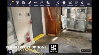
Picha za skrini
Bado hakuna picha za skrini zilizopakiwa. Je, unamiliki biashara hii?
Pakia picha za skrini.Video za YouTube
Video kutoka kwa kituo rasmi cha YouTube
(2 videos)

Maelezo
LinkedIn:
Tembelea
YouTube:
Tembelea
Facebook:
Tembelea
X:
Tembelea
Instagram:
Tembelea
Mwaka Imara:
2012
Bei:
$0-$999/mo
Aina ya Mtumiaji:
B2B
Dot3D Sifa Kuu
Beji
Ongeza mamlaka yako ya SaaS kwa kutumia mojawapo ya beji zetu
Dot3D Njia Mbadala
Contractor Foreman Imetangazwa
This comprehensive construction management platform streamlines the coordinat...
Pythagoras
This software suite provides comprehensive tools for surveying, mapping, cons...
3Dsurvey
This comprehensive software solution specializes in photogrammetry, mapping, ...
Carlson
This comprehensive land surveying and civil engineering software suite offers...
NUBIGON
This software facilitates the visualization, analysis, and presentation of co...
Undet
This software suite offers advanced tools for converting, visualizing, and an...
Ajile
This advanced 3D imaging and measurement system leverages high-resolution, fu...
RecFusion
This system enables real-time 3D digitization and modeling using RGB-D sensor...
SkyeBrowse
This innovative software transforms video footage into detailed 3D models, en...
Gundua zaidi katika kategoria hii:
Teknolojia Zinazotumika
Squarespace
reCAPTCHA
MailChimp
Zoho
Adobe Fonts
Google Tag Manager
Tailwind
HTML5
Angular
WordPress
Wix Content Delivery Network (CDN)
Programu ya Ushirika
Programu ya Ushirika:
Jiunge na Programu ya Ushirika
* Google inajitahidi kutoa maelezo sahihi, yaliyosasishwa kuhusu nyenzo zisizo salama za wavuti lakini haiwezi kuhakikisha ukamilifu au matokeo yasiyo na hitilafu.
** Baadhi au sehemu zote za ukurasa huu zinaweza kuzalishwa na AI, kwa hivyo tafadhali thibitisha taarifa zozote muhimu kwa kujitegemea.
Imedaiwa Hivi Karibuni
Ufikiaji wa Barua Pepe & Zana za Utumaji Barua Pepe baridi
Usimamizi na Upangaji wa Mitandao ya Kijamii
Utambuzi na Uchanganuzi wa Huduma ya Afya unaoendeshwa na AI
Usimamizi na Upangaji wa Mitandao ya Kijamii
Usalama wa Wingu na Zana za Uzingatiaji
Programu ya Kufuatilia Wakati na Tija
Programu ya Uendeshaji wa Uuzaji
Programu ya Utimilifu na Usafirishaji wa Agizo
Zana za Kuchunguza Rejea zinazoendeshwa na AI
Usimamizi wa Kazi na Orodha ya Programu za Orodha ya Mambo ya Kufanya
Imeongezwa Hivi Karibuni
Pollarix
Maoni ya Wateja & Programu ya Uchunguzi
CogSeven Companion
Madaftari na Majukwaa ya Sayansi ya Data
Candid
Majukwaa ya Utafiti ya Kisheria yanayoendeshwa na AI
MaxyService
Usimamizi wa Duka la Urekebishaji
ViZuTrade
Majukwaa ya Biashara ya Hisa na Udalali
Alerta
Programu ya Mawasiliano ya Ndani
Surface
Programu ya HRIS na Core HR
Pluggie
Programu ya Ufikiaji wa Kompyuta ya Mbali na Ufikiaji wa Mbali
PainCanvas
Ufuatiliaji wa Afya na Siha
MQCL-CRM
CRM (Usimamizi wa Uhusiano wa Wateja)
Kategoria 10 Bora Mwezi Huu
1.
Programu ya Uendeshaji wa Uuzaji
+856
Idadi ya bidhaa mpya za SaaS zilizoongezwa kwenye kategoria hii katika siku 30 zilizopita.
2.
Majukwaa ya Usimamizi ya Blockchain & NFT
+592
Idadi ya bidhaa mpya za SaaS zilizoongezwa kwenye kategoria hii katika siku 30 zilizopita.
3.
Usimamizi wa Hati na Zana za eSignature
+522
Idadi ya bidhaa mpya za SaaS zilizoongezwa kwenye kategoria hii katika siku 30 zilizopita.
4.
Avatar pepe zinazoendeshwa na AI na Wasaidizi wa Dijitali
+497
Idadi ya bidhaa mpya za SaaS zilizoongezwa kwenye kategoria hii katika siku 30 zilizopita.
5.
Usalama wa Wingu na Zana za Uzingatiaji
+493
Idadi ya bidhaa mpya za SaaS zilizoongezwa kwenye kategoria hii katika siku 30 zilizopita.
6.
Zana za Kuchunguza Rejea zinazoendeshwa na AI
+489
Idadi ya bidhaa mpya za SaaS zilizoongezwa kwenye kategoria hii katika siku 30 zilizopita.
7.
Utambuzi na Uchanganuzi wa Huduma ya Afya unaoendeshwa na AI
+445
Idadi ya bidhaa mpya za SaaS zilizoongezwa kwenye kategoria hii katika siku 30 zilizopita.
8.
Majukwaa ya Utafiti ya Kisheria yanayoendeshwa na AI
+433
Idadi ya bidhaa mpya za SaaS zilizoongezwa kwenye kategoria hii katika siku 30 zilizopita.
9.
Majukwaa ya Kujifunza na Elimu
+426
Idadi ya bidhaa mpya za SaaS zilizoongezwa kwenye kategoria hii katika siku 30 zilizopita.
10.
Programu ya Usimamizi wa Meli
+422
Idadi ya bidhaa mpya za SaaS zilizoongezwa kwenye kategoria hii katika siku 30 zilizopita.
Takwimu za Kivinjari cha SaaS
Imeongezwa Siku 30 Zilizopita
+21,811
Idadi ya bidhaa mpya za SaaS zilizogunduliwa na kuongezwa kwenye hifadhidata yetu katika siku 30 zilizopita.
SaaS Inayotumika
468,001
Jumla ya idadi ya bidhaa za SaaS zilizochapishwa na zinazotumika ambazo kwa sasa zimeorodheshwa katika injini yetu ya utafutaji.
Jumla katika Hifadhidata
1,296,182
Jumla ya idadi ya bidhaa zote za SaaS katika hifadhidata yetu, ikijumuisha maingizo ambayo hayajachapishwa na yaliyoachwa kuchapishwa.
Jiunge na Kivinjari cha SaaS Bila Malipo
Tumia vichujio vyote vya hali ya juu bila malipo
Dhibiti orodha zako za SaaS
Unda arifa za bure kwa SaaS mpya
Imefadhiliwa
Strikingly
Wajenzi wa Tovuti
Castmagic
Uandishi wa Nakala na Uzalishaji wa Maudhui wa AI
plusvibe
Ufikiaji wa Barua Pepe & Zana za Utumaji Barua Pepe baridi
Singing Carrots
Programu za Kujifunza Lugha zinazoendeshwa na AI
Snov
Programu ya Uendeshaji wa Uuzaji
Hello Audio
Upangishaji wa Podcast & Majukwaa ya Usambazaji
Clockify
Programu ya Kufuatilia Wakati na Tija
FlipperForce
Uwekezaji wa Ardhi na Programu ya Kugeuza Ardhi
WalletCalcs
Zana za Mipango ya Fedha na Bajeti
SmartTask
Usimamizi wa Kazi wa Mbali na Ufuatiliaji wa Tija
Usikose, kuwa wa kwanza kujua!
Bidhaa mpya za SaaS zinazinduliwa kila siku, 21,811 imeongezwa katika siku 30 zilizopita pekee. Endelea kupata taarifa, na uwe wa kwanza kujua wakati SaaS mpya inayolingana na hoja yako ya utafutaji itagunduliwa na SaaS Browser.
Ingia ili kuweka arifa za barua pepe kwa SaaS mpya zinazofanana na utafutaji wako.
Ingia ili Kuunda Arifa
Gundua zana zinazofanana
Vinjari zote →