تصدیق شدہ اور اپ ڈیٹ پروفائل حاصل کریں۔
دعوی کردہ پروفائلز تلاش کے نتائج کے اوپر جاتے ہیں۔ ابھی توثیق کریں، اس میں صرف چند منٹ لگتے ہیں۔
وزٹ کریں۔
رپورٹ
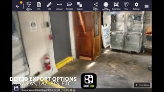
This three-dimensional scanning application provides precise control over accuracy, enabling detailed and extensive capture of large-scale scenes such as buildings, roadways, and infrastructure. Its key features include automatic optimization algorithms for post-processing, seamless integration with high-precision GNSS devices for geo-referencing, support for adding coded targets and reference measurements to improve accuracy, and the ability to handle virtually unlimited scene sizes with rapid local processing and compatibility with desktop data editing—making it ideal for professionals in architecture, surveying, construction, and engineering seeking efficient, reliable, and scalable 3D data acquisition and analysis.
Dot3D میں پایا جا سکتا ہے۔ Architectural Design & Drafting Software زمرے
Dot3D سے ملتی جلتی مصنوعات ہیں:
اسکرین شاٹس
ابھی تک کوئی اسکرین شاٹس اپ لوڈ نہیں کیے گئے ہیں۔ کیا آپ اس کاروبار کے مالک ہیں؟
اسکرین شاٹس اپ لوڈ کریں۔یوٹیوب ویڈیوز
آفیشل یوٹیوب چینل سے ویڈیوز
(2 videos)

تفصیلات
LinkedIn:
وزٹ کریں۔
YouTube:
وزٹ کریں۔
Facebook:
وزٹ کریں۔
X:
وزٹ کریں۔
Instagram:
وزٹ کریں۔
سال قائم ہوا۔:
2012
قیمتوں کا تعین:
$0-$999/mo
صارفین کی قسم:
B2B
Dot3D اہم خصوصیات
بیجز
ہمارے بیجز میں سے ایک کے ساتھ اپنی SaaS اتھارٹی میں اضافہ کریں۔
Dot3D متبادل
Contractor Foreman ترقی دی گئی۔
This comprehensive construction management platform streamlines the coordinat...
Pythagoras
This software suite provides comprehensive tools for surveying, mapping, cons...
3Dsurvey
This comprehensive software solution specializes in photogrammetry, mapping, ...
Carlson
This comprehensive land surveying and civil engineering software suite offers...
NUBIGON
This software facilitates the visualization, analysis, and presentation of co...
Undet
This software suite offers advanced tools for converting, visualizing, and an...
Ajile
This advanced 3D imaging and measurement system leverages high-resolution, fu...
RecFusion
This system enables real-time 3D digitization and modeling using RGB-D sensor...
SkyeBrowse
This innovative software transforms video footage into detailed 3D models, en...
اس زمرے میں مزید دریافت کریں۔:
استعمال شدہ ٹیکنالوجیز
Squarespace
reCAPTCHA
MailChimp
Zoho
Adobe Fonts
Google Tag Manager
Tailwind
HTML5
Angular
WordPress
Wix Content Delivery Network (CDN)
ملحق پروگرام
ملحق پروگرام:
ملحق پروگرام میں شامل ہوں۔
* Google غیر محفوظ ویب وسائل کے بارے میں درست، تازہ ترین معلومات فراہم کرنے کی کوشش کرتا ہے لیکن مکمل یا غلطی سے پاک نتائج کی ضمانت نہیں دے سکتا۔
** اس صفحہ کے کچھ یا تمام حصے AI سے تیار کیے جا سکتے ہیں، لہذا براہ کرم کسی بھی اہم معلومات کی آزادانہ طور پر تصدیق کریں۔
حال ہی میں دعویٰ کیا گیا۔
ٹائم ٹریکنگ اور پروڈکٹیوٹی سافٹ ویئر
اپوائنٹمنٹ شیڈولنگ سافٹ ویئر
بزنس انٹیلی جنس اور تجزیات
بزنس انٹیلی جنس اور تجزیات
ایمیزون ایف بی اے ٹولز
لیڈ جنریشن سافٹ ویئر
مالیاتی منصوبہ بندی اور بجٹ سازی کے اوزار
ٹاسک مینجمنٹ اور ٹو ڈو لسٹ ایپس
AI سے چلنے والے قانونی تحقیقی پلیٹ فارمز
پے رول مینجمنٹ سافٹ ویئر
حال ہی میں شامل کیا گیا۔
SentinelMesh
آٹو ایم ایل پلیٹ فارمز
Cortexa
دماغی صحت اور علاج کے پلیٹ فارمز
eyeView
پنچ لسٹ اور جمع کرانے والے سافٹ ویئر
Outreach
ای میل آؤٹ ریچ اور کولڈ ای میلنگ ٹولز
Infloxy
متاثر کن مارکیٹنگ اور آؤٹ ریچ ٹولز
Listing Optimization AI
ایمیزون ایف بی اے ٹولز
SaamDigitals
ایس ایم ایس اور واٹس ایپ مارکیٹنگ ٹولز
PrepNiz
سیکھنے اور تعلیم کے پلیٹ فارم
Listloops
ریئل اسٹیٹ سی آر ایم اور لیڈ مینجمنٹ
reflec7
مائنڈ میپنگ سافٹ ویئر
اس مہینے کی ٹاپ 10 کیٹیگریز
1.
سیلز آٹومیشن سافٹ ویئر
+856
پچھلے 30 دنوں میں اس زمرے میں شامل کیے گئے نئے SaaS پروڈکٹس کی تعداد۔
2.
بلاکچین اور این ایف ٹی مینجمنٹ پلیٹ فارمز
+592
پچھلے 30 دنوں میں اس زمرے میں شامل کیے گئے نئے SaaS پروڈکٹس کی تعداد۔
3.
دستاویز کا انتظام اور ای دستخطی ٹولز
+522
پچھلے 30 دنوں میں اس زمرے میں شامل کیے گئے نئے SaaS پروڈکٹس کی تعداد۔
4.
AI سے چلنے والے ورچوئل اوتار اور ڈیجیٹل اسسٹنٹ
+497
پچھلے 30 دنوں میں اس زمرے میں شامل کیے گئے نئے SaaS پروڈکٹس کی تعداد۔
5.
کلاؤڈ سیکیورٹی اور تعمیل کے ٹولز
+493
پچھلے 30 دنوں میں اس زمرے میں شامل کیے گئے نئے SaaS پروڈکٹس کی تعداد۔
6.
AI سے چلنے والے ریزیوم اسکریننگ ٹولز
+489
پچھلے 30 دنوں میں اس زمرے میں شامل کیے گئے نئے SaaS پروڈکٹس کی تعداد۔
7.
AI سے چلنے والی تشخیص اور صحت کی دیکھ بھال کے تجزیات
+445
پچھلے 30 دنوں میں اس زمرے میں شامل کیے گئے نئے SaaS پروڈکٹس کی تعداد۔
8.
AI سے چلنے والے قانونی تحقیقی پلیٹ فارمز
+433
پچھلے 30 دنوں میں اس زمرے میں شامل کیے گئے نئے SaaS پروڈکٹس کی تعداد۔
9.
سیکھنے اور تعلیم کے پلیٹ فارم
+426
پچھلے 30 دنوں میں اس زمرے میں شامل کیے گئے نئے SaaS پروڈکٹس کی تعداد۔
10.
فلیٹ مینجمنٹ سافٹ ویئر
+422
پچھلے 30 دنوں میں اس زمرے میں شامل کیے گئے نئے SaaS پروڈکٹس کی تعداد۔
SaaS براؤزر کے اعدادوشمار
پچھلے 30 دنوں میں شامل کیا گیا۔
+21,811
پچھلے 30 دنوں میں ہمارے ڈیٹا بیس میں دریافت اور شامل کیے گئے نئے SaaS پروڈکٹس کی تعداد۔
ایکٹو ساس
468,001
شائع شدہ اور فعال SaaS مصنوعات کی کل تعداد جو فی الحال ہمارے سرچ انجن میں ترتیب دی گئی ہے۔
ڈیٹا بیس میں کل
1,296,182
ہمارے ڈیٹا بیس میں SaaS پروڈکٹس کی کل تعداد، بشمول غیر مطبوعہ اور بند شدہ اندراجات۔
مفت میں SaaS براؤزر میں شامل ہوں۔
تمام جدید فلٹرز مفت میں استعمال کریں۔
اپنی SaaS فہرستوں کا نظم کریں۔
نئے SaaS کے لیے مفت الرٹس بنائیں
سپانسر شدہ
Folderly
ای میل مارکیٹنگ سافٹ ویئر
OutOnSite
ایمپلائی آن بورڈنگ اور ٹریننگ سافٹ ویئر
Smodin
AI سے چلنے والی تحریر اور کاپی جنریشن
UiCore
ویب سائٹ بنانے والے
iFax
دستاویز کا انتظام اور ای دستخطی ٹولز
StoryChief
مواد کی مارکیٹنگ کے پلیٹ فارمز
Clockify
ٹائم ٹریکنگ اور پروڈکٹیوٹی سافٹ ویئر
Pulse
CRM (کسٹمر ریلیشن شپ مینجمنٹ)
Ziggma
انویسٹمنٹ پورٹ فولیو مینجمنٹ
Harpoon
مالیاتی منصوبہ بندی اور بجٹ سازی کے اوزار
مت چھوڑیں، جاننے والے پہلے بنیں!
نئی SaaS پروڈکٹس ہر روز لانچ ہو رہی ہیں، صرف پچھلے 30 دنوں میں 21,811 کو شامل کیا گیا۔ باخبر رہیں، اور یہ جاننے والے پہلے فرد بنیں کہ SaaS براؤزر کے ذریعہ آپ کی تلاش کے استفسار سے مماثل نیا SaaS کب دریافت ہوتا ہے۔
اپنی تلاش سے ملنے والے نئے SaaS کے لیے ای میل الرٹ ترتیب دینے کے لیے سائن ان کریں۔
الرٹ بنانے کے لیے سائن ان کریں
ملتے جلتے ٹولز کو دریافت کریں۔
سب کو براؤز کریں۔ →