InSite Software
Construction Takeoff Software
Get Verified & Update Profile
Claimed profiles go to the top of search results. Get verified now, it takes just a couple minutes.
Visit
Report
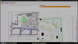
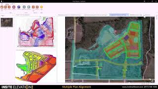
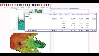
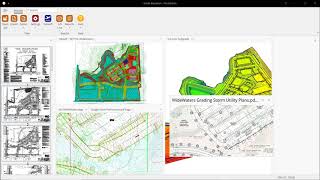
This software solution streamlines the process of earthwork and utility estimation by providing accurate takeoff and GPS modeling capabilities, enabling professionals to efficiently manage complex site calculations. Key features include support for CAD, PDF, and drone data integration, precise quantity validation through advanced contour mapping, and seamless export to various machine control systems, ultimately solving challenges related to time management, accuracy, and communication for estimators and construction professionals.
InSite Software can be found in Construction Takeoff Software categories.
The most similar products to InSite Software are:
Screenshots
No screenshots have been uploaded yet. Do you own this business?
Upload screenshotsYouTube Videos
Videos from the official YouTube channel
(20 videos)


Details
InSite Software Main Features
InSite Software Benefits
Who should use InSite Software?
Verified Badge
Share our verified badge on your website
InSite Software Alternatives
Contractor Foreman Promoted
This comprehensive construction management platform streamlines the coordinat...
Carlson
This comprehensive land surveying and civil engineering software suite offers...
Rockpile Solutions
A comprehensive software suite that optimizes workflows, automates repetitive...
3Dsurvey
This comprehensive software solution specializes in photogrammetry, mapping, ...
Promine
This software suite enhances the efficiency and accuracy of mining and survey...
Pythagoras
This software suite provides comprehensive tools for surveying, mapping, cons...
Stringer
This software enhances productivity and accuracy in civil engineering and lan...
Buildsoft
This software suite streamlines the estimating and takeoff processes for cons...
Explore more in this category:
Technologies Used
Google reCAPTCHA
Yeost SEO Plugin
Tailwind
Cloudflare
WordPress
Google Site Verification
Google Tag Manager for WordPress (GTM4WP)
Gravity Forms
HTML5
reCAPTCHA
Wix Content Delivery Network (CDN)
WordPress Block Editor (Gutenberg)
WordPress REST API
WP Engine
Google Fonts
Slick Slider
Capterra
* Google strives to provide accurate, up-to-date info on unsafe web resources but can't guarantee completeness or error-free results.
** Some or all parts of this page may be AI generated, so please verify any critical information independently.
Recently Claimed
Learning and Education Platforms
School Management Software
Invoicing & Payment Processing
App Store Optimization (ASO)
Cloud Security & Compliance Tools
Inventory & Warehouse Management
CRM (Customer Relationship Management)
PDF Editing & Conversion Tools
Health & Fitness Tracking
Equipment Rental Software
Recently Added
Tierex
Cloud Security & Compliance Tools
Vigilon Monitoring
Network Monitoring Software
Zaatly
Sales Automation Software
Omni
Marketing Automation Platforms
ViaCatalyst
Data Warehouse & Data Lake Platforms
PSConfigurator
Product Configurator Software
DoorForce
Facility Management Software
UniBMA
Time & Attendance Software
viaBanking
Core Banking Software
Ataris
Cloud Infrastructure & IaaS Platforms
Top 10 Categories This Month
1.
Stock Trading & Brokerage Platforms
+1,053
Number of new SaaS products added to this category in the past 30 days.
2.
Workflow Automation & RPA
+827
Number of new SaaS products added to this category in the past 30 days.
3.
AI-powered Resume Screening Tools
+594
Number of new SaaS products added to this category in the past 30 days.
4.
AutoML Platforms
+528
Number of new SaaS products added to this category in the past 30 days.
5.
Sales Automation Software
+477
Number of new SaaS products added to this category in the past 30 days.
6.
Financial Planning & Budgeting Tools
+449
Number of new SaaS products added to this category in the past 30 days.
7.
AI-powered Virtual Avatars & Digital Assistants
+415
Number of new SaaS products added to this category in the past 30 days.
8.
School Management Software
+401
Number of new SaaS products added to this category in the past 30 days.
9.
Health & Fitness Tracking
+395
Number of new SaaS products added to this category in the past 30 days.
10.
Restaurant POS & Management Systems
+336
Number of new SaaS products added to this category in the past 30 days.
SaaS Browser Stats
Added Past 30 Days
+35,678
Number of new SaaS products discovered and added to our database in the last 30 days.
Active SaaS
483,714
Total number of published and active SaaS products currently indexed in our search engine.
Total in Database
1,357,376
Total number of all SaaS products in our database, including unpublished and discontinued entries.
Join SaaS Browser for Free
Use all advanced filters for free
Manage your SaaS listings
Create free alerts for new SaaS
Sponsored
Oh Dear
Website Monitoring, Uptime & Performance
Tagshop
AI-powered Ad Creatives & Video Generation
FinalScout
Email Outreach & Cold Emailing Tools
BrandMentions
Media Monitoring & Social Listening
Castmagic
Copywriting & AI Content Generation
Usermaven
People Analytics Software
Postwise
Social Media Management & Scheduling
Xtensio
Creative Management Platforms
Mailshake
Marketing Automation Platforms
Recapture
Email Marketing Software
Don't miss out, be the first to know!
New SaaS products are launching every day, 35,678 added in the last 30 days alone. Stay informed, and be the first to know when new SaaS matching your search query is discovered by SaaS Browser.
Sign in to set up email alerts for new SaaS matching your search.
Sign In to Create Alert
Explore similar tools
Browse all →